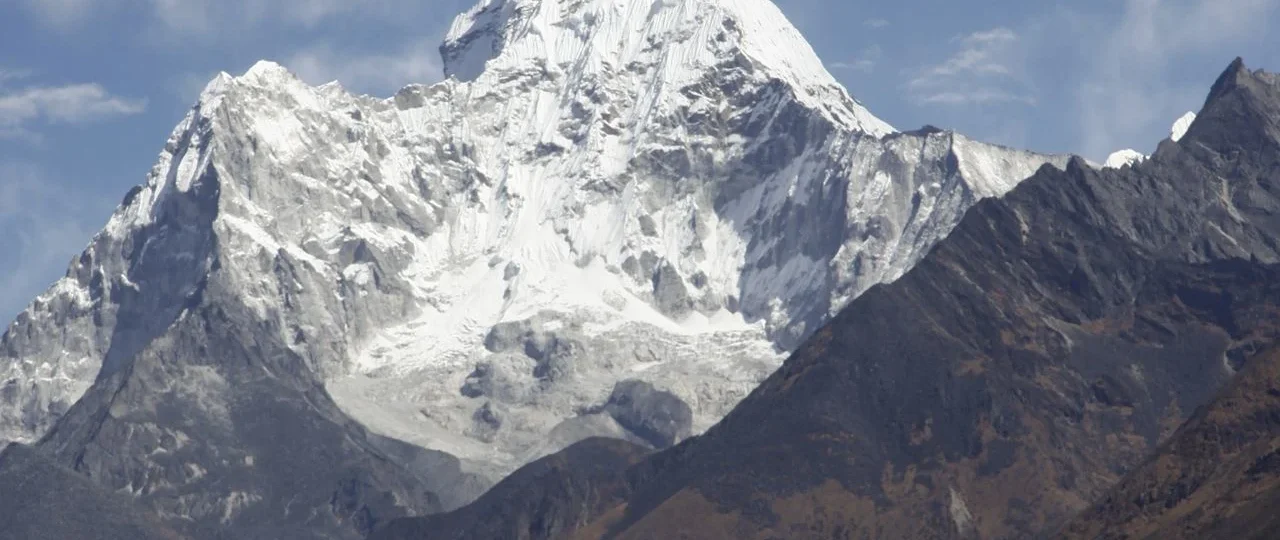
Ama Dablam Base Camp
Ama Dablam sits at roughly 4,600 metres on a grassy shelf beneath the mountain’s West Face in Nepal’s Khumbu region. It is a seasonal staging ground for climbing expeditions, not a permanent village. During spring and autumn, the meadow fills with expedition tents, dining shelters, and climbers preparing for summit pushes. Outside those windows, it reverts to a quiet, wind-scoured field with a single stone shelter and panoramic views across the Everest massif.
The distinction between trekking to base camp and climbing Ama Dablam is the single most misunderstood aspect of this route. Reaching the base camp does not mean climbing the mountain. It means walking to the foot of it. The trek tops out at approximately 4,600 metres. The summit stands at 6,812 metres. Everything between those two figures involves technical rock, ice, and mixed climbing — crampons, ice axes, fixed ropes, and weeks of expedition logistics.
Most trekkers who visit base camp do so as a side trip from Pangboche, a traditional Sherpa village at 3,980 metres on the main Everest Base Camp trail. The journey from Pangboche to the base camp meadow takes five to six hours uphill and three to four hours back down. It is a moderate day hike, not an expedition. The reward is one of the closest, most dramatic mountain views in the entire Khumbu — Ama Dablam’s hanging glacier suspended above you like a lantern, its twin ridgelines framing the sky. Several sources describe the base camp elevation as 4,570 metres, while others cite 4,600 metres or 4,650 metres. The variation reflects different measurement points across the base camp area, GPS device discrepancies, and rounding conventions. For planning purposes, treat 4,600 metres as your working figure.
The name Ama Dablam translates roughly as “Mother’s Charm Box.” Ama refers to the two long ridges that frame the peak like a mother’s embracing arms. Dablam is the traditional Sherpa pendant worn by women, containing small images of Buddhist deities — a reference to the hanging glacier high on the mountain’s face. The peak is often called the “Matterhorn of the Himalaya” for its distinctive pyramid profile, though that comparison undersells its scale and setting.

Quick Facts:
| Detail | Information |
|---|---|
| Location | Khumbu region, Solukhumbu District, eastern Nepal |
| Base camp elevation | Approximately 4,570–4,650 metres (commonly cited as 4,600m) |
| Ama Dablam summit | 6,812 metres |
| Nearest village | Pangboche (3,980m), a 5–6 hour walk uphill |
| Trek duration | 8–13 days from Kathmandu, depending on itinerary |
| Difficulty | Moderate — no technical climbing |
| Accommodation | Teahouse lodges in villages; day visit to base camp (no overnight camping on most treks) |
| Best season | Spring (March–May) and autumn (October–November) |
| Permits | Sagarmatha National Park entry + Khumbu Pasang Lhamu Rural Municipality fee |
| Climbing permit | Not required for base camp trekking |
| Start point | Lukla (flight from Kathmandu or Manthali/Ramechhap) |
Sits and Why Its Location Matters
The base camp is tucked into the upper Imja Khola valley, directly beneath Ama Dablam’s West Face. It is accessed from Pangboche via a side trail that leaves the main Everest Base Camp route, crosses the Imja Khola River on a suspension bridge, and climbs through alpine pastures and rocky moraine terrain.
Pangboche itself is one of the last permanent Sherpa settlements before the trail enters the high, glacier-carved upper Khumbu. The village has two sections — Upper Pangboche and Lower Pangboche — connected by stone paths and terraced fields where locals grow potatoes and barley. The Pangboche Monastery, believed to be the oldest in the Khumbu region, sits above the village and adds a cultural anchor to the trek. Because Pangboche is above the tree line, the landscape is open, dry, and stripped of forest cover. This is where trekkers feel they have genuinely entered the high Himalayan zone.
The geography here matters for understanding the trek’s difficulty. The Imja Khola drains meltwater from glaciers beneath Everest, Lhotse. Valley walls are steep. The terrain is rocky and exposed. Weather can shift quickly, even during peak season. But the trail itself is well-defined and non-technical — a walking route, not a climbing route.
Pangboche to Ama Dablam Base Camp: The Day That Defines the Trek
This is the segment that most online guides describe poorly. Here is what actually happens.
Distance: Approximately 7–10 kilometres round-trip, depending on the exact route and how much time you spend wandering at base camp.
Elevation gain: Roughly 620–670 metres, from Pangboche (3,980m) to base camp (~4,600m).
Walking time: The uphill section typically takes five to six hours. The descent takes three to four hours. Total round-trip walking time is seven to eight hours.
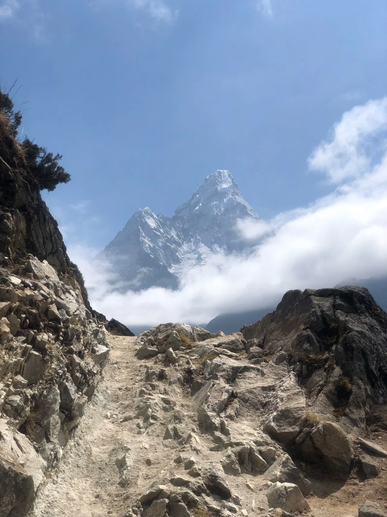
Terrain: The trail leaves Pangboche, crosses the Imja Khola via a suspension bridge, and climbs steadily through alpine pastures and rocky terrain. There are no technical sections — no scrambling, no fixed ropes, no glacier travel. But the altitude makes every step feel heavier than it would at lower elevations.
What you see at base camp: During the spring climbing season (late March through May), you will likely encounter expedition teams, their tents, dining shelters, and climbers preparing gear. The atmosphere is focused but welcoming. In autumn (October–November), the autumn climbing season brings a similar scene. Outside these windows, base camp is quiet — just the meadow, the stone shelter, and the mountain.
Recommendation: Treat this as a day hike from Pangboche rather than an overnight. Sleeping at 4,600 metres without proper acclimatization increases the risk of acute mountain sickness. Most responsible itineraries return to Pangboche for the night.
Trek Difficulty: Who This Route Suits — And Who It Doesn’t
The maximum sleeping altitude on most itineraries is Pangboche at 3,980 metres, or Namche Bazaar at 3,440 metres on shorter versions. The base camp visit reaches 4,600 metres, but you return to lower elevation the same day. This altitude profile is significantly more forgiving than Everest Base Camp, where you sleep at 5,164 metres at Gorak Shep.
What makes this trek accessible:
The daily walking distances are manageable — typically four to six hours, with one longer day from Phakding to Namche. Accommodation is in teahouses, not tents. No climbing equipment is required. No previous mountaineering experience is needed. The route follows the well-established Everest Base Camp trail as far as Pangboche, so navigation is straightforward.
What makes it challenging:
You are walking above 3,500 metres for several consecutive days. The day from Pangboche to base camp involves a sustained climb at altitude. Terrain includes rocky paths, suspension bridges, and steep sections. Weather can change without warning. And altitude — not fitness — is the great equalizer. Trekkers who have had altitude sickness before face a 60–70 percent recurrence rate, according to one trekking operator.
Who this trek suits: Fit beginners who want a taste of the Everest region without committing to the full EBC itinerary. Trekkers with limited time — eight to ten days rather than two weeks. Photographers drawn to Ama Dablam’s profile. Experienced trekkers seeking a quieter alternative to the main EBC corridor. Anyone considering a future Ama Dablam expedition who wants to see the approach first.
Who might struggle: Trekkers with no prior high-altitude experience. Those who cannot handle consecutive days of uphill walking. Anyone unwilling to accept basic teahouse conditions — shared bathrooms, limited menu, cold nights.
Suggested Itinerary: 8 to 10 Days from Kathmandu
| Day | Route | Altitude | Walking Time |
|---|---|---|---|
| 1 | Fly Kathmandu → Lukla; trek to Phakding | 2,610m | 3–4 hours |
| 2 | Phakding → Namche Bazaar | 3,440m | 5–6 hours |
| 3 | Acclimatization day in Namche (hike to Everest View Hotel) | 3,440m | 2–3 hours |
| 4 | Namche → Tengboche | 3,860m | 5–6 hours |
| 5 | Tengboche → Pangboche | 3,980m | 3–4 hours |
| 6 | Pangboche → Ama Dablam Base Camp → Pangboche | 4,600m | 7–8 hours round trip |
| 7 | Pangboche → Namche | 3,440m | 6–7 hours |
| 8 | Namche → Lukla | 2,860m | 6–7 hours |
| 9 | Fly Lukla → Kathmandu | 1,350m | — |
Some operators extend the itinerary with additional acclimatization days, an overnight at base camp, or a return via a different route through Khumjung village. Itinerary length varies from eight to thirteen days depending on the operator and inclusions. A well-paced itinerary with at least one acclimatization day at Namche is the minimum for comfort and safety.
Acclimatization: What Actually Matters on This Route
Altitude is the variable that most affects whether you enjoy this trek or endure it. The good news is that the Ama Dablam Base Camp route is designed around gradual ascent. The Namche acclimatization day — where you sleep at 3,440 metres for two nights — is the most important single day of the itinerary. It gives your body time to produce more red blood cells and adjust to reduced oxygen availability.
Key principles:
Walk slowly. The standard Nepali advice — bistari, bistari — is physiology, not politeness. At altitude, your body needs more time to do the same work. Pushing pace at 3,500 metres is the fastest way to trigger symptoms.
Drink water — three to four litres per day. Dehydration mimics and worsens altitude symptoms. Avoid alcohol entirely during the first three to four days at altitude.
Monitor your symptoms honestly. Headache, nausea, dizziness, and breathlessness at rest are early warning signs of acute mountain sickness. If they appear, stop ascending. If they worsen, descend. Descent is the only reliable treatment for serious altitude illness.
The altitude profile on this trek is more forgiving than Everest Base Camp because you sleep lower. But 4,600 metres is still high enough to cause problems if you ascend too quickly or ignore symptoms. The base camp day visit is the high point — and you return to Pangboche afterward. That descent makes a significant difference.
Best Time to Trek
Spring (March–May) and autumn (October–November) are the two reliable windows.
Spring brings warmer temperatures, blooming rhododendrons, and the spring climbing season on Ama Dablam. Expedition teams set up at base camp from late March. Trails are quieter than autumn. The downside is that afternoon clouds often obscure mountain views, so early starts matter.
Autumn offers the clearest skies of the year, stable weather, and excellent visibility. It is the peak trekking season in the Khumbu, so expect more trekkers on the main EBC trail — though the Ama Dablam side trail from Pangboche remains relatively quiet. The autumn climbing season also brings expeditions to base camp.
Winter (December–February) treks are possible but cold. Some teahouses above Namche may close. Snow can obscure trails and increase the risk of slips.
Monsoon (June–August) is not recommended. Heavy rain, landslides, leeches, and poor visibility make the trek unpleasant and, in some sections, dangerous.
Permits and Fees for 2026
Two permits are required for the Dablam Base Camp Trek. No climbing permit is needed for base camp trekking — that applies only to expeditions attempting the summit.
Sagarmatha National Park Entry Permit: approximately NPR 3,000 for foreign nationals, NPR 1,500 for SAARC nationals, NPR 100 for Nepali citizens.
Khumbu Pasang Lhamu Rural Municipality Entry Fee: approximately NPR 2,000–3,000 for foreign trekkers. This local fee has replaced the TIMS card requirement for most treks within the Khumbu region. Some operators still list TIMS as included, but the municipality fee serves the same purpose for this route.
Climbing permit: Not required for base camp trekking. A summit attempt on Dablam requires a climbing permit costing USD 1,000 per person as of 2025 revisions, plus a garbage deposit.
Always verify current fees with your trekking agency before booking. Permit costs change, and the Khumbu municipality fee has been adjusted in recent seasons.
Cost: What You’ll Actually Pay
Package prices for the Dablam Base Camp Trek vary by operator, group size, itinerary length, and inclusions. Based on current 2026 listings, you can expect:
| Package Type | Approximate Price Range |
|---|---|
| Budget group trek (8–9 days) | USD 1,000–1,300 |
| Mid-range group trek (10–12 days) | USD 1,300–1,800 |
| Private trek (custom itinerary) | USD 1,800–2,500+ |
Several operators list starting prices around USD 1,050–1,220 for standard group departures. A 14-day premium option with private comfort camps is listed at USD 2,590 by one international operator.
What drives cost variation: group size (private treks cost more per person), itinerary length (more days equals higher cost), accommodation level (standard teahouse versus upgraded lodges), inclusions (flights, permits, meals, guide, porter), and season (peak season prices are higher).
What is typically included: airport transfers, Kathmandu hotel nights, Lukla flights, permits, teahouse accommodation, meals during the trek, licensed guide, and a porter (usually one porter per two trekkers).
What is typically excluded: international flights, Nepal visa, travel insurance, personal gear, tips, drinks, hot showers, WiFi, and any costs arising from delays or itinerary changes. Always request a detailed inclusions and exclusions list before booking.
Accommodation and Food on the Trek
Accommodation is in teahouse lodges — family-run mountain guesthouses with basic but comfortable rooms. Rooms are usually twin-share with shared bathrooms. Hot showers are available at most lodges for an extra fee. WiFi is available but slow and sometimes unreliable. Power outages are common.
At base camp itself, the only options are a seasonal stone shelter or tented camping. Most trekkers do not sleep at base camp — they return to Pangboche for the night.
Food follows the standard trekking menu: dal bhat, noodles, momos, Tibetan bread, eggs, potatoes, and tea. Dal bhat is the best value — usually unlimited refills and designed to fuel a day of walking. Meat is available but often not fresh at higher altitudes; vegetarian options are generally safer and better. In Pangboche specifically, you will find Tibetan dishes alongside Nepali staples.
Packing Essentials
| Category | Essentials |
|---|---|
| Clothing | Moisture-wicking base layers, fleece or softshell mid-layer, down jacket, waterproof shell, trekking trousers, warm hat, gloves, sunglasses |
| Footwear | Broken-in hiking boots with ankle support, camp shoes or sandals |
| Gear | 40–50L daypack, sleeping bag (rated to -10°C or lower), trekking poles, headlamp, water bottles or bladder |
| Health | First aid kit, blister care, Diamox (consult doctor), sunscreen, lip balm, electrolyte tablets |
| Documents | Passport, passport photos, permits, insurance details, cash |
Pack layers, not bulk. Temperatures can swing from warm at midday to below freezing at night. A waterproof shell is non-negotiable. Bring more cash than you think you need — there are no reliable ATMs above Namche.
Altitude Sickness: Recognition and Response
Acute Mountain Sickness affects a significant proportion of trekkers above 3,500 metres. Symptoms include headache, nausea or vomiting, dizziness, fatigue, breathlessness at rest, loss of appetite, and difficulty sleeping.
If symptoms appear, stop ascending. Rest and hydrate. Take Diamox if you have a prescription (consult a doctor before the trek). Descend if symptoms worsen or do not improve within 24 hours. Seek immediate medical help if symptoms are severe — confusion, inability to walk, or fluid in the lungs.
The best prevention is gradual ascent, adequate acclimatization days, and honest self-monitoring. Do not ignore symptoms because you are fit or because you have paid for the trek.
Ama Dablam Base Camp vs. Everest Base Camp: An Honest Comparison
| Factor | Ama Dablam Base Camp | Everest Base Camp |
|---|---|---|
| Maximum altitude | ~4,600m | 5,364m (5,545m at Kala Patthar) |
| Trek duration | 8–13 days | 12–16 days |
| Difficulty | Moderate | Moderate to challenging |
| Crowds | Quieter side trail | Busy main corridor |
| Mountain views | Ama Dablam dominates; Everest visible from Tengboche and Namche | Everest, Lhotse, Nuptse, Khumbu Glacier |
| Acclimatization risk | Lower | Higher |
| Cultural experience | Sherpa villages, Tengboche, Pangboche | Sherpa villages, Tengboche, Khumjung, Namche |
| Best for | Shorter trips, lower altitude, photography | Bucket-list achievement, Everest proximity |
Everest Base Camp sits 794 metres higher than Ama Dablam Base Camp, and in high-altitude trekking, those metres are not linear. The physiological stress at 5,364 metres is significantly greater than at 4,600 metres. The EBC trek also covers roughly 130 kilometres round trip, compared to approximately 60 kilometres for the Ama Dablam route.
If your goal is to stand at the foot of Everest, no alternative will substitute. But if you want a quieter, shorter, lower-altitude trek through the same Sherpa villages with arguably more dramatic close-up mountain views, Ama Dablam Base Camp is the stronger choice. Many trekkers combine the two — trekking to Ama Dablam as a side trip from Pangboche while on the EBC route.
Sherpa Culture Along the Route
The Khumbu is the homeland of the Sherpa people, and the trek passes through some of their most important villages. Namche Bazaar is the commercial and cultural hub. Tengboche is the spiritual centre, home to a monastery that has been rebuilt after earthquake damage and remains an active place of worship. Pangboche is older, quieter, and home to the region’s oldest monastery.
Tibetan Buddhism shapes daily life. Prayer flags, mani walls, and chortens mark the trail. Yak caravans still carry supplies to higher villages. The Sherpa people are historically traders and farmers who became famous as mountaineers — a reputation earned through generations of experience at altitude. Engaging respectfully with this culture is part of what makes the trek meaningful. Learn a few words of Nepali or Sherpa. Ask before photographing people. Remove your shoes before entering a monastery.
Photography:
Ama Dablam is widely considered the most photogenic peak in the Khumbu. Its sharp, snow-draped pyramid rises dramatically above the surrounding ridges, and its profile changes significantly depending on your viewpoint.
Best viewpoints include the trail between Namche and Tengboche (first clear views), Tengboche Monastery (classic composition with prayer flags), Pangboche (the mountain dominates the skyline), and Ama Dablam (dramatic close-up of the West Face).
A telephoto lens (70–200mm) is useful for compressing the mountain against the sky. A wide-angle lens captures the base camp environment and surrounding peaks. Bring spare batteries — cold drains them quickly. Early morning and late afternoon offer the best light. The mountain catches golden light at sunrise and sunset, while midday light tends to be harsh.
Planning Your Trek with Wonder Hikes Nepal
Ama Dablam Base Camp is a straightforward trek in good conditions and a complicated one when weather, altitude, or logistics go sideways. The difference between a smooth journey and a stressful one often comes down to local knowledge and current information.
Wonder Hikes Nepal operates treks in the Everest region with licensed local guides who know the route, the teahouses, and the acclimatization challenges. They can help you plan an itinerary that fits your timeline and fitness level, arrange permits and Lukla flights, assign a guide who monitors your acclimatization and adjusts the pace if needed, and build flexibility into the schedule for weather or altitude-related changes.
If you are considering the Ama Dablam Base Camp Trek, contact Wonder Hikes Nepal for current route information, itinerary options, and practical advice. They will tell you what is actually possible — not just what is advertised.
Frequently Asked Questions
1. What is the altitude of Ama Dablam Base Camp?
Most sources cite approximately 4,600 metres. Some use 4,570m or 4,650m. For trekking purposes, treat it as around 4,600m.
2. Do I need climbing experience to trek to Ama Dablam Base Camp?
No. The trek is a moderate walking route. No technical climbing skills or equipment are required.
3. How difficult is the Ama Dablam Base Camp Trek?
Moderate. The main challenge is altitude, not technical terrain. Fitness helps, but acclimatization matters more.
4. How long does the trek take?
Typically 8–13 days from Kathmandu to Kathmandu, depending on itinerary and acclimatization days.
5. How far is Ama Dablam Base Camp from Pangboche?
Approximately 7–10 kilometres round-trip. Walking time is 5–6 hours uphill and 3–4 hours down.
6. Can I trek to Ama Dablam Base Camp without a guide?
While not legally mandatory for this route, a licensed guide adds significant safety and logistical value. Most trekkers book through an agency.
7. What permits do I need?
Sagarmatha National Park entry permit and Khumbu Pasang Lhamu Rural Municipality fee. No climbing permit is required for base camp trekking.
8. How much does the trek cost?
Package prices range from approximately USD 1,000 to USD 2,500+, depending on group size, itinerary length, and inclusions.
9. Is Ama Dablam Base Camp harder than Everest Base Camp?
No. The maximum altitude is lower (4,600m vs. 5,364m), the trek is shorter, and the altitude gain is more gradual. Most trekkers find it more accessible.
10. Can I combine Ama Dablam Base Camp with Everest Base Camp?
Yes. The side trip from Pangboche adds approximately one day to the standard EBC itinerary.
11. What is the best time to trek?
Spring (March–May) and autumn (October–November). Autumn offers the clearest skies; spring is slightly quieter.
12. Where do I sleep on the trek?
Teahouse lodges in villages along the route. Most trekkers return to Pangboche after visiting base camp rather than sleeping at 4,600m.
13. What should I pack?
Layers, waterproofs, broken-in boots, sleeping bag, trekking poles, headlamp, first aid kit, Diamox (consult doctor), and cash.
14. Is altitude sickness a risk?
Yes. 4,600 metres is high enough to cause AMS. Acclimatize properly, walk slowly, hydrate, and descend if symptoms worsen.
15. Can beginners do this trek?
Fit beginners can complete it, but altitude tolerance varies. Training before the trek and following acclimatization protocols improve the experience significantly.
Ready to plan your trek?
Tell us your dates and group size. We reply on WhatsApp within a few hours.