-
Hotel, Lodge
-
Kathmandu
-
Spring, Autumn
-
Guided
-
4,984 m
-
Drive, Flight
The Langtang Valley Trek is the shortest way to stand deep inside the high Nepal Himalaya without an internal flight, a restricted-area permit, or a two-week commitment. You drive north from Kathmandu, walk up a single glacial valley for a few days, and end at Kyanjin Gompa (3,870 m), a monastery settlement ringed by peaks over 7,000 metres. From there, two viewpoints — Kyanjin Ri and Tserko Ri — put the entire Langtang range at eye level.
This page covers the 10-day version of the trek: what it costs, exactly where you sleep each night, how hard it is, which permits you need in 2026, and the practical details that decide whether your trek goes smoothly or badly. We have kept the itinerary conservative on purpose. Faster 7- and 8-day versions exist and are sold everywhere, but the two extra days here buy you proper acclimatisation and a real chance to see both viewpoints — which is the point of coming.
Where a figure can change between now and your departure (permit fees, road conditions, the guide rule), we say so and tell you where to confirm it, rather than printing a number that may already be wrong.
Langtang Valley Trek Quick Facts
| Detail | Information |
|---|---|
| Trek | Langtang Valley Trek |
| Duration | 10 days (Kathmandu to Kathmandu) |
| Trek days on foot | 6 walking days + 1–2 exploration/acclimatisation days |
| Start / End | Syabrubesi (approx. 1,460–1,550 m) |
| Highest point | Tserko Ri, approx. 4,984 m (optional) |
| Highest sleeping altitude | Kyanjin Gompa, approx. 3,870 m |
| Total walking distance | ~70–80 km round trip (excluding side hikes) |
| Difficulty | Moderate |
| Region | Langtang National Park, Rasuwa District, north-central Nepal |
| Accommodation | Tea houses (guesthouses) along the trail |
| Access | Road only — 6–8 hour drive from Kathmandu, no domestic flight |
| Permits | Langtang National Park entry permit + TIMS card (see permits section — status changes) |
| Best seasons | Mid-March to May; late September to November |
| Guide | Required in 2026 under current rules — confirm before you travel |
Trek Overview
Langtang sits in a steep glacial valley north of Kathmandu, close to the Tibetan border, inside Langtang National Park — Nepal’s first Himalayan national park, gazetted in 1976 and covering roughly 1,710 square kilometres across the Rasuwa, Nuwakot and Sindhupalchowk districts.
The route is an out-and-back up the Langtang Khola (river). You start low, at around 1,460–1,550 metres in Syabrubesi, and climb through three distinct zones in three days: humid subtropical forest in the gorge, then rhododendron and pine, then open high-altitude yak pasture above the treeline. That vertical range is why the trek feels bigger than its modest distances suggest — you pass through several climate bands on the way up.
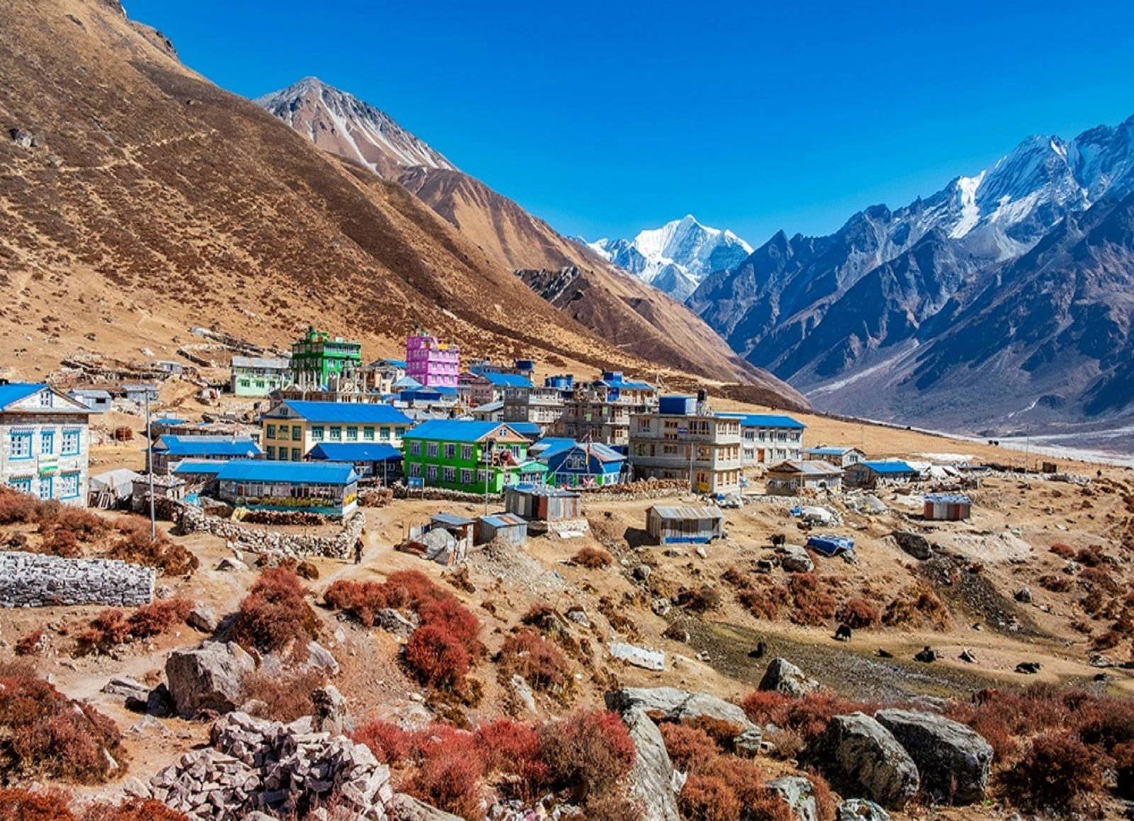
The valley reaches its natural end at Kyanjin Gompa, a small settlement built around a Buddhist monastery and a working yak-cheese factory. Most trekkers spend two nights here, using the extra day to climb Kyanjin Ri or Tserko Ri for the panorama: Langtang Lirung (7,227 m), Langtang Ri, Dorje Lakpa, Gangchenpo and the Langtang glacier feeding the valley below.
The population here is predominantly Tamang, with strong Tibetan-Buddhist cultural roots — prayer walls, chortens and monasteries line the trail. This is not a backdrop invented for tourism; it is a living community, and one that carries a recent, heavy history.
In April 2015, an earthquake-triggered ice-and-rock avalanche buried the old Langtang Village and killed a large part of its population and many visitors. The village you walk through today was rebuilt on and near the debris field. Trekkers who understand this arrive with more respect and, usually, a better experience.
Langtang is often described as “beginner-friendly,” and relative to Everest Base Camp or the Annapurna Circuit that is fair. But it is still a Himalayan trek that crosses 4,000 metres, and altitude does not care how short the itinerary is. Treat it as moderate, not easy.
Why the 10-day Langtang Valley itinerary
Six walking days get you up and down. The version sold as 7 or 8 days does exactly that. The 10-day plan adds two things that matter:
- A gentler ascent profile, so you are not gaining 1,000+ metres of sleeping altitude in a single push.
- Two full days at Kyanjin Gompa, which lets you climb Kyanjin Ri on one day and Tserko Ri on the next — and gives you a weather buffer, because high viewpoints get clouded out and you often need a second morning.
If you have the time, the extra two days are the cheapest insurance you will buy for this trek.
Why Choose This Package
There is no shortage of companies selling this route, so the honest question is what actually differs between a good operator and a cheap one. These are the things worth paying for on Langtang specifically:
- Proper pacing built into the plan, not sold as an “upgrade.” A safe acclimatisation profile is the single biggest predictor of whether you summit a viewpoint feeling good or turn back with a headache. A responsible itinerary bakes it in.
- A guide who knows this valley, not just “a guide.” Langtang has real hazards — landslide-prone sections below Lama Hotel in the wet season, and unstable terrain around the 2015 slide zone. Local knowledge of when and where to move matters here more than on gentler trails.
- Honest inclusions. Cheap quotes usually exclude the drive back, the permits, or the guide’s insurance, and the gap appears on the trail. The inclusions and exclusions further down this page show what a complete price should contain.
- Support for the local economy. Langtang’s villages were rebuilt by their own people after 2015. Staying in locally-owned tea houses and eating local food is not a slogan here — it is how the valley recovers.
If a quote is far cheaper than everyone else’s, look at what has been removed rather than assuming you found a bargain
Langtang Valley Trek Itinerary at a glance
| Day | Route | Altitude (approx.) | Walking |
|---|---|---|---|
| 1 | Arrive Kathmandu | 1,400 m | — |
| 2 | Drive to Syabrubesi | 1,550 m | 6–8 hrs (road) |
| 3 | Syabrubesi → Lama Hotel | 2,480 m | 5–6 hrs |
| 4 | Lama Hotel → Langtang Village | 3,430 m | 5–6 hrs |
| 5 | Langtang Village → Kyanjin Gompa | 3,870 m | 3–4 hrs |
| 6 | Kyanjin Ri hike, return to Kyanjin Gompa | 4,773 m | 4–5 hrs |
| 7 | Tserko Ri hike / valley walk, return to Kyanjin Gompa | up to 4,984 m | up to 7–8 hrs |
| 8 | Kyanjin Gompa → Lama Hotel | 2,480 m | 6–7 hrs |
| 9 | Lama Hotel → Syabrubesi | 1,550 m | 5–6 hrs |
| 10 | Drive to Kathmandu | 1,400 m | 6–8 hrs (road) |
Langtang Valley Trek Permits
Langtang is an open trekking region — it does not require a restricted-area permit. In 2026 you generally need two documents, plus one situational third:
1. Langtang National Park Entry Permit. This is the core permit and is checked at Dhunche and at Ghodatabela. Indicative 2026 fees:
| Trekker category | Approx. fee |
|---|---|
| Foreign nationals (non-SAARC) | NPR 3,000 (about USD 25) [VERIFY] |
| SAARC nationals | NPR 1,500 [VERIFY] |
| Nepali citizens | NPR 100 [VERIFY] |
| Children under 10 | Free |
The fee is the same regardless of season or group size, and it is charged once per entry.
2. TIMS Card (Trekkers’ Information Management System). The TIMS requirement for Langtang has changed more than once — it was dropped for the region, then reinstated in various forms — so its status is the single most-confused permit question for this trek. In 2026 most operators arrange it as standard. Indicative foreign-national cost is roughly NPR 1,000 (group) to NPR 2,000 (individual) [VERIFY]. Confirm the current requirement and fee before you travel, ideally through your agency or the Nepal Tourism Board.
3. Shivapuri Nagarjun National Park Entry Permit — only if you enter or exit via the Gosaikunda/Helambu route. Not needed for the standard Syabrubesi in-and-out itinerary on this page.
The guide requirement
Under rules applied to Langtang National Park in 2025, all trekkers are expected to be accompanied by a licensed guide arranged through a registered trekking agency, and permits are issued on that basis. Reports on how strictly this is enforced on the ground have varied, and Nepal’s trekking regulations have been in flux — a separate 2026 change, for example, now lets solo foreigners obtain restricted-area permits without a partner. Because this specific rule affects whether you can trek Langtang independently at all, check the current status before planning a solo, unguided trip. Do not assume last year’s situation still holds.
Practical notes that do not change:
- Carry your original passport plus photocopies and 2 passport photos for permit issuance.
- Permit offices take payment in Nepalese Rupees only.
- Keep permits in a waterproof pouch and accessible — checkpoints record them, and you will be turned back without valid documents no matter how far you have walked.
- Permits generally are not available online; they are issued in Kathmandu or at the trailhead
Difficulty of Langtang Valley Trek
Langtang is a moderate trek. It is realistic for a fit first-time trekker, but it is not a walk in the park, and the “easy” label sold online sets some people up to underestimate it.
What makes it moderate rather than easy:
- Sustained daily ascents. The climb from Lama Hotel up to Langtang Village is a solid effort at altitude, and several sections are steep and rocky.
- The high side hikes. Kyanjin Ri and especially Tserko Ri (near 5,000 m) are demanding — steep, long, and on thin air.
- The long descent. Coming down from Kyanjin Gompa to Lama Hotel in a day is hard on knees and legs.
- Altitude. Crossing 4,000 m and, optionally, nearly 5,000 m is the real challenge, not the horizontal distance.
What keeps it accessible: no technical climbing, no glacier travel on the main route, a clear well-used trail, tea houses every few hours, and — thanks to the road access — no need to gain altitude by flying into a high airstrip.
Fitness Requirements
You do not need to be an athlete, but you should be able to walk 5–7 hours a day on hills, on consecutive days, carrying a daypack. The people who struggle most are usually those who did no preparation and assumed a “short” trek meant an easy one.
A sensible 6–8 week build-up:
- Cardio, 3–4 times a week: hiking, running, cycling or stair climbing. Aim to comfortably sustain an hour or more.
- Long training hikes at weekends, ideally on hills, wearing the boots and daypack you will use. Break your boots in now, not on Day 3.
- Leg and core strength: squats, lunges and step-ups build the muscles you need for both the climbs and the punishing descents.
- Back-to-back days: train two or three days in a row occasionally, because that is what the trek is.
If you have a heart or lung condition, or any concern about high altitude, get medical clearance before you book.
Altitude and Acclimatization
This is the part of the trek that genuinely matters for your safety, and the reason the 10-day itinerary exists.
Above roughly 3,000 metres, the thinner air can cause Acute Mountain Sickness (AMS). On Langtang, the risk zone begins around Langtang Village and climbs through Kyanjin Gompa and the viewpoints. AMS is not about fitness — strong, fit people get it too — it is about how fast you ascend.
Early symptoms to know and take seriously: headache, nausea, loss of appetite, dizziness, poor sleep, and unusual fatigue. Mild symptoms are common and manageable. The danger is ignoring worsening symptoms and continuing to climb.
How this itinerary reduces the risk:
- The short Day 5 into Kyanjin Gompa limits sleeping-altitude gain.
- The two nights at Kyanjin let you “climb high, sleep low” on the Kyanjin Ri and Tserko Ri days.
- The pace is deliberately unhurried on the ascent.
What you should do:
- Drink 3–4 litres of water a day.
- Walk slowly and steadily — pace beats power at altitude.
- Avoid alcohol, especially on the way up.
- Tell your guide about symptoms early and honestly. This is not the place to be stoic.
- The only reliable treatment for worsening AMS is to descend. Losing a few hundred metres of altitude usually resolves it quickly. Descending is a success, not a failure.
Some trekkers use acetazolamide (Diamox) as a preventive or treatment aid — discuss this with a doctor before your trip, not on the trail.
Weather and Climate
Weather in Langtang shifts with both season and altitude. On a single day you can start in warm forest and finish in near-freezing wind above the treeline, so you dress in layers regardless of the forecast.
| Season | Months | Conditions |
|---|---|---|
| Spring | Mid-March – May | Warm days, blooming rhododendron, generally clear mornings; one of the two best windows |
| Monsoon | June – August | Heavy rain, leeches, landslides and cloud-obscured views; not recommended |
| Autumn | Late Sept – November | Crisp, stable, excellent visibility; the most popular season |
| Winter | December – February | Cold, quiet, often snow around Kyanjin Gompa; beautiful but harsh, some tea houses close |
Mornings are almost always clearer than afternoons in the mountains, which is why the high viewpoints are done at or before dawn.
Best Time for Langtang Valley Trek
The two prime seasons are mid-March to May (spring) and late September to November (autumn).
- Autumn gives the most reliable clear skies and mountain views, and is the busiest and most social time on the trail.
- Spring brings warmer temperatures and the rhododendron forests in full bloom, with views that are usually excellent if slightly hazier than autumn.
Winter is for experienced, cold-tolerant trekkers who want solitude and don’t mind snow and closed lodges. Monsoon (June–August) is best avoided on Langtang specifically — the forested lower valley is landslide-prone and leech-heavy, and clouds hide the peaks you came to see. If monsoon is your only option, build extra buffer days in for road and trail delays.
Accommodation
You sleep in tea houses — family-run trailside lodges that are the backbone of Nepali trekking. Expect a simple twin room with two beds, a mattress, pillow and blankets, and a communal dining room heated by a stove (often the warmest place in the building and the social hub each evening).
What to know:
- Rooms are basic and cheap because the real income is from meals — you are expected to eat at the lodge where you sleep.
- Bathrooms are usually shared; attached bathrooms exist in lower villages but become rare higher up.
- It gets colder and simpler with altitude. A good sleeping bag (rated to around −10°C) is worth carrying — blankets alone can fall short at Kyanjin Gompa.
- In peak season, rooms fill up. A guide who calls ahead is a genuine advantage.
- Since 2015, lodges in Langtang Village and Kyanjin Gompa have been rebuilt to better standards, and the trail infrastructure has largely recovered.
Meals
Trail food is hearty, carbohydrate-heavy and built to fuel long walking days. The reliable staple is dal bhat — rice, lentil soup, vegetable curry and pickles — and it comes with free refills almost everywhere, which is why experienced trekkers swear by it.
Typical menus also include:
- Noodles, fried rice, pasta and Tibetan bread
- Momos (dumplings), soups and potato dishes
- Porridge, eggs, chapati and pancakes for breakfast
- Tea, coffee and hot lemon throughout the day
Two things worth knowing. First, prices rise as you climb, because every item is carried up by porter or mule — this is fair, not a scam. Second, eat mostly vegetarian on the trail. Meat is carried up unrefrigerated over several days; at altitude, sticking to dal bhat and vegetable dishes is the safer choice. The Kyanjin cheese factory is the one local specialty worth trying — yak cheese, made on the spot.
Transportation
Langtang’s biggest logistical advantage is that it is reached entirely by road — no domestic flight, no flight delays, no weather-grounded planes.
- Private jeep: the recommended option. Faster (6–7 hours), more comfortable, and flexible on departure time and stops. The cost of the vehicle is split across your group.
- Public bus: the budget choice. Cheaper but slower (8+ hours), crowded, and less comfortable on the rough later sections.
The road to Syabrubesi is scenic but narrow and winding, with rough patches — especially after monsoon damage. Take motion-sickness medication in advance if you need it, and treat the drive as part of the adventure rather than a formality. Always allow for the possibility of delays on the return leg.
Drinking Water
Staying hydrated is central to avoiding altitude sickness, so plan your water properly.
- Do not drink untreated tap or stream water.
- Buying bottled water is discouraged. It is expensive higher up, and the discarded plastic is a serious problem in the valley.
- The responsible and cheaper approach: carry a treatment method and refill along the way. Options include water-purification tablets, a UV purifier (such as a SteriPEN), or a filter bottle. Boiled water is also available at tea houses for a small charge.
- Carry at least 2 litres of capacity, and drink steadily through the day rather than in occasional large amounts.
A reusable bottle plus purification tablets is the simplest, lightest, most reliable combination for this trek.
Internet and Electricity
- Charging: tea houses provide electricity, but charging your devices usually costs a small fee per hour, and availability gets less reliable with altitude. Bring a power bank and charge it whenever you can. A solar charger is a useful backup in good weather.
- Wi-Fi: available at many tea houses for a fee, but it is slow and unreliable, particularly higher up. Do not count on it for anything important.
- Mobile signal: an NTC (Nepal Telecom) SIM gives the best coverage and generally works up to Kyanjin Gompa, though it drops out on the high ridges. A local SIM bought in Kathmandu is cheap and worth having for basic contact.
- Cold drains batteries fast. At altitude, keep your phone and power bank inside your sleeping bag overnight so they hold charge.
Money and ATMs
Carry enough cash for the whole trek. There are no ATMs on the trail. The last reliable machines are in Kathmandu; Syabrubesi may have limited options but you should not rely on them.
- Bring Nepalese Rupees in cash — permits, tea houses and extras are all cash-only on the route.
- Budget for meals, drinks, hot showers, charging, Wi-Fi, snacks and tips, and add a contingency margin for delays or an emergency.
- Keep cash in small denominations; change for large notes is scarce in the mountains.
- Store money in more than one place, and keep it dry.
Solo Travellers
Langtang has long been popular with solo and independent trekkers because it is close to Kathmandu, the trail is easy to follow, and it has no restricted-area barrier.
However, current rules for Langtang National Park require trekkers to be accompanied by a licensed guide, arranged through a registered agency — which changes the picture for anyone planning to go completely alone. Because Nepal’s trekking regulations have shifted repeatedly (including a 2026 change relaxing the solo rule for restricted areas), confirm the current Langtang requirement before you plan an unguided trip.
Even where regulations allow it, a guide on Langtang is a sound choice: weather changes fast, snow can hide the trail, and having someone who knows the valley — and can act quickly in a medical or altitude emergency — is worth far more than the daily fee. Solo travellers who trek with a guide still get plenty of independence and the social side of the tea-house trail.
Safety
Langtang is a well-established, well-supported trek, but “supported” is not the same as “risk-free.”
- Altitude is the primary risk. Follow the acclimatisation guidance above, and act early on symptoms.
- Terrain and landslides: the forested section below Lama Hotel can be landslide-prone in and after monsoon. In peak dry seasons the risk is low; in the wet, your guide’s judgement on timing and routing matters.
- The 2015 slide zone around Langtang Village is stable and rebuilt, but it is a reminder that this is active mountain terrain.
- Weather: conditions can turn quickly at altitude. Carry proper layers even on clear mornings.
- Communication: tell someone your itinerary, carry a charged phone with a local SIM, and know that helicopter evacuation is possible from the valley — but only if your insurance covers it.
The most important safety tool is a conservative pace and the willingness to descend or turn back. No viewpoint is worth pushing through serious symptoms.
Insurance
Travel insurance with high-altitude and helicopter-evacuation cover is effectively mandatory for this trek — do not go without it.
Check specifically that your policy:
- Covers trekking up to at least 5,000 metres. Tserko Ri is near 4,984 m, and many standard policies exclude activity above 3,000 or 4,000 m. Read the altitude clause carefully.
- Includes emergency helicopter evacuation and rescue. In a serious altitude or injury situation in this valley, a helicopter may be the only way out, and the cost without cover is severe.
- Covers medical treatment and repatriation.
- Ideally covers trip cancellation and delay, given how weather and roads can disrupt plans.
Carry your policy number and the insurer’s emergency contact somewhere accessible, and give a copy to your operator. Confirm the details in writing before you pay for the policy — the altitude and evacuation clauses are exactly where cheap policies fall short.
Responsible Tourism
Langtang is not an abstract case study in sustainable travel. This valley lost much of its community and infrastructure in 2015 and rebuilt largely through its own people and the tourism that returned. How you trek here has a direct effect.
- Stay and eat locally. Choosing locally-owned tea houses and eating local food keeps money in the villages that need it.
- Cut plastic. Treat your own water instead of buying bottles; carry out what you carry in. Waste management on the trail is limited.
- Respect the culture. This is a Buddhist region — walk clockwise around chortens and mani walls, ask before photographing people, and dress modestly in villages and monasteries.
- Employ and tip fairly. Guides and porters carry your trek on their backs; fair wages and customary tips matter.
- Tread lightly. Stay on the trail, don’t disturb wildlife, and keep noise down near settlements and monasteries.
Good conduct here is not decoration — it is part of why the valley is walkable again.
Wildlife
Langtang National Park protects a genuinely rich range of Himalayan wildlife across its forest, meadow and high-alpine zones. Species recorded in the park include the red panda, snow leopard, Himalayan tahr, musk deer, Himalayan black bear, and langur and rhesus monkeys, alongside more than 250 species of birds — including Nepal’s national bird, the Danphe (Himalayan monal).
Realistic expectations matter: snow leopards and red pandas are elusive and very rarely seen. What you are far more likely to encounter are monkeys in the lower forest, tahr on the higher slopes, colourful pheasants, and the domestic yaks that graze the pastures around Kyanjin. Early mornings in the forest sections offer the best chance of birds and mammals — move quietly and keep your eyes on the treeline.
Culture
The Langtang Valley is home mainly to the Tamang people, with deep Tibetan-Buddhist roots that are visible everywhere on the trail — prayer flags, carved mani stones, chortens, water-driven prayer wheels and monasteries.
The cultural high point is Kyanjin Gompa, the monastery that gives the settlement its name, alongside the working yak-cheese factory established with Swiss support decades ago. In the villages you will see traditional stone-and-timber houses, yak herding, and a way of life shaped by high-altitude farming and, now, trekking.
Engage respectfully and the culture becomes one of the richest parts of the trek: accept a cup of butter tea if it is offered, learn a few words of Nepali or Tamang, and take time to understand the recent history rather than treating the villages as scenery. The people here are welcoming, and the trek is far more rewarding when you meet them as neighbours rather than a backdrop.
Photography Tips
Langtang rewards photographers who are up early and patient.
- Shoot at dawn. Mornings are clearest; by afternoon the peaks are usually clouded. This is why Kyanjin Ri and Tserko Ri are done at or before sunrise.
- The high viewpoints are the money shots. From Tserko Ri and Kyanjin Ri you get the full sweep of the Langtang range in first light — worth the cold, dark climb.
- Protect your gear from cold and dust. Cold flattens batteries fast (keep spares warm inside your jacket), and the dry trail throws up dust — carry a lens cloth.
- A polarising filter helps enormously with the harsh high-altitude light and deepens those blue skies.
- Photograph people only with permission, especially at monasteries and in villages. A moment of asking earns a far better portrait than a stolen one.
- Look beyond the peaks: prayer flags against snow, yaks on the pasture, the cheese factory, forest light in the lower valley, and the rebuilt village all tell the fuller story of Langtang.
Cost Breakdown
Langtang is one of Nepal’s better-value treks, mostly because there is no flight. What you pay depends heavily on style — a fully independent budget trekker and a client on a private guided package can spend very different amounts on the identical trail.
Rather than print a single package price that will be out of date, here is where the money actually goes. Treat these as 2026 planning ranges and confirm live figures with your operator.
| Cost component | Indicative range | Notes |
|---|---|---|
| Langtang National Park permit | ~NPR 3,000 / USD 25 (foreigners) | once per entry |
| TIMS card | ~USD 8–17 | Status/price varies |
| Transport (Kathmandu ↔ Syabrubesi) | Public bus ~USD 8–15 each way; private jeep ~USD 200–260 per vehicle | Jeep split across a group is affordable and far more comfortable. |
| Guide | ~USD 25–40 per day | Required under current rules |
| Porter (optional) | ~USD 20–30 per day | One porter typically carries for two trekkers |
| Tea-house accommodation | ~USD 3–8 per night | Rooms are cheap; owners expect you to eat where you sleep |
| Meals on the trail | ~USD 20–35 per day | Rises with altitude as everything is carried up |
| Extras | Variable | Hot showers, device charging, Wi-Fi, boiled water, snacks — all charged per use and increase higher up |
As a rough guide, a fully independent budget trekker often lands around USD 25–45 per day on the trail (excluding permits and transport), while an all-inclusive private guided package — covering guide, permits, transport, accommodation and meals — typically works out higher per day but removes every logistical headache. Get any quote itemised so you can see exactly what is and is not included.