

Introduction to Fishtail Peak Nepal
Fishtail Peak Nepal is the nickname of Machapuchare, the 6,993-metre mountain that rises above Pokhara in the Annapurna region. It is one of the most photographed peaks in the country, and it has a distinction most travellers do not expect: nobody is allowed to climb it. The only confirmed attempt, in 1957, stopped just short of the summit, and no climbing permits have been issued since.
You can still get remarkably close without a rope or an ice axe. This guide explains what Fishtail Peak is, why it is off limits, where to see it from, which treks bring you nearest, and when the views are best.
Fishtail Peak Nepal at a Glance
If you only need the essentials, start here. The short answer to the question people ask most is that you cannot summit Fishtail Peak, but you can view it from Pokhara and walk to its base camp on the Annapurna Base Camp trek.
| Detail | What to know |
|---|---|
| Names | Machapuchare, Machhapuchhre, Fishtail. The Nepali name means “fishtail”, and the Gurung name is Katasuṅ Klikō. |
| Height | 6,993 m (22,943 ft) |
| Prominence | 1,233 m |
| Range and province | Annapurna massif, Gandaki Province |
| Distance from Pokhara | About 25 km north |
| Climbing status | Unclimbed. Ascents are not allowed. |
| Closest confirmed approach | About 46 m (150 ft) below the summit, in 1957 |
| Where trekkers get closest | Machapuchare Base Camp (about 3,700 m) on the Annapurna Base Camp route, and the Mardi Himal ridge |
Why It Is Called Fishtail
The name describes the summit. Machapuchare has a double summit, and from some angles the two points look like the forked tail of a fish. The Nepali word for fishtail gives the mountain its name, and the Gurung people who live on its slopes use their own name, Katasuṅ Klikō.
The shape is only part of the story. The peak stands at the end of a long spur that runs south from the main Annapurna ridge. Because it sits so far south, and because the land south of the range is low, it rises steeply from the foothills in a short horizontal distance. That dramatic relief, together with its steep, pointed profile, is why it looks bigger than some of its higher neighbours. It is sometimes called the Matterhorn of Nepal for the same reason.
Why Fishtail Peak Is Sacred
The climbing ban makes more sense once you know what the mountain means locally. Machapuchare is regarded as holy by the Gurung people and by the people of Chhomrong, the village on the trail beneath it. It is said to be the home of the god Shiva, and some Hindu devotees treat the peak itself as a deity rather than a geographic feature.
That belief explains the terms of the 1957 expedition and the policy that followed. It also changes how you should behave as a visitor. You are walking through Gurung villages, and the mountain above them is a place of worship for many residents. Keep to the trail, take your rubbish with you, ask before photographing people and treat the base camp as a viewpoint, not a staging post for anything more ambitious.
Can You Climb Fishtail Peak?
No. The highest point of Machapuchare has never been officially climbed, because the government of Nepal does not issue permits to climb it. If you see a trekking agency selling a Fishtail summit, treat it as a red flag.
The 1957 expedition
The only confirmed attempt took place in 1957. A British team led by Lieutenant Colonel Jimmy Roberts went to the mountain, and climbers Wilfrid Noyce and A. D. M. Cox reached a point within about 46 metres (150 ft) of the summit via the north ridge, at roughly 6,947 metres. King Mahendra had given the team permission to climb but forbade them from setting foot on the summit itself, and the climbers kept to those terms. Noyce later published an account of the expedition, and his piece in the Alpine Journal remains the main climbing record.
What happened afterwards
No permits have been issued since that expedition. You may come across a claim that a New Zealand climber reached the summit illegally in the early 1980s. This is reported but not confirmed, so it does not change the official picture. Travel pages also give different dates and details for the mountain’s climbing history, and some repeat figures that do not match the published record. The 1957 attempt is the one with a documented account.
For more background on the mountain’s history and status, see the Machapuchare entry on Wikipedia.
What to do instead
If you came looking for a Himalayan summit, Nepal has plenty of legal options, from trekking peaks to expedition-level mountains. Our guide to mountaineering in Nepal covers peaks, permits and costs. If you came for the view, keep reading, because Fishtail is easy to see.
Myths and facts
| Claim you may read | What the record shows |
|---|---|
| You can buy a permit to summit Fishtail. | No permits have been issued since the 1957 expedition, and ascents are not allowed. |
| Machapuchare Base Camp is a climbing base camp. | It is a trekking stop at about 3,700 m on the Annapurna Base Camp route. |
| Fishtail is the highest mountain in the Annapurna region. | Annapurna I, at 8,091 m, is far higher. Fishtail stands at 6,993 m and looks larger because of its steep relief. |
| You have to trek to see it. | You can see it from Pokhara, Phewa Lake and Sarangkot without any trekking. |
Where Fishtail Peak Is Located
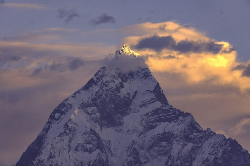
Machapuchare stands in the Annapurna massif in north-central Nepal, in Gandaki Province. It sits at the southern end of a long spur ridge that comes off the main Annapurna backbone and forms the eastern boundary of the Annapurna Sanctuary. The peak is about 25 km north of Pokhara, the provincial capital, which is why it dominates the skyline there.
The sanctuary behind it is a favourite trekking destination and the site of base camps for Annapurna’s south face. That geography explains why the Annapurna Base Camp trek passes directly beneath Fishtail.
Neighbouring peaks you will see with it
Fishtail rarely appears alone. Depending on where you stand, these peaks share the view.
| Peak | Height | Where you see it with Fishtail |
|---|---|---|
| Dhaulagiri I | 8,167 m | Sarangkot |
| Manaslu | 8,163 m | Sarangkot on clear days |
| Annapurna I | 8,091 m | Sarangkot |
| Annapurna II | 7,937 m | Sarangkot |
| Gangapurna | 7,455 m | Ghandruk |
| Annapurna South | 7,219 m | Ghandruk, Sarangkot and the Mardi Himal ridge |
| Hiunchuli | 6,441 m | Ghandruk and the Mardi Himal ridge |
The Best Places to See Fishtail Peak
You do not need to trek to see it. Several viewpoints work for different amounts of time and effort.
| Viewpoint | Effort | What you get |
|---|---|---|
| Phewa Lake, Pokhara | Easy, no early start | The mountain reflected in the water on a clear day |
| Sarangkot (about 1,600 m) | Easy, early start | Sunrise panorama of Annapurna, Dhaulagiri and Fishtail |
| World Peace Pagoda | Easy | Views of the Annapurna range and Phewa Lake |
| Ghandruk (about 2,012 m) | Easy to moderate | Close views of Annapurna South and Fishtail from a Gurung village |
| Poon Hill (3,210 m) | Short trek | Sunrise over the Annapurna range with Fishtail in view |
| Mardi Himal ridge | Trek of several days | Close-up views from the ridge |
| Machapuchare Base Camp (about 3,700 m) | Part of Annapurna Base Camp trek | The mountain looming directly overhead |
From Pokhara and Phewa Lake
Pokhara owes much of its appeal to this view. On a clear day Fishtail reflects on the water of Phewa Lake, and a boat trip is one of the classic things to do in town. Early morning is the most reliable time, because clouds tend to build later in the day. The light on the peak changes at sunrise and again at sunset, so a second visit at dusk gives you another chance if the morning was cloudy. For planning your stay, our Pokhara Lakeside guide covers what to see and do.
From Sarangkot
Sarangkot is the standard sunrise viewpoint. It sits at about 1,600 metres and gives a wide view of the Annapurna and Dhaulagiri ranges, with Fishtail close and prominent, and Phewa Lake below. The drive from Pokhara takes roughly 30 to 40 minutes, and most visitors leave around 4:30 to 5:00 a.m. Sunrise falls between roughly 5:15 a.m. in summer and 6:45 a.m. in winter, so check the time for your date.
There is no trekking permit needed for the Sarangkot to Naudada ridge walk, though the viewpoint itself may charge a small entry fee. In peak season the viewpoint gets crowded, but there is usually enough space to find a spot if you arrive early. Sarangkot is also a popular paragliding launch, which gives another way to see the mountain.
From the World Peace Pagoda and Ghandruk
The World Peace Pagoda above Phewa Lake offers views of the Annapurna range and the lake, and it suits a half-day visit. If you have an extra day or two, Ghandruk, a Gurung village at about 2,012 metres, offers close views of Annapurna South, Fishtail, Gangapurna and Hiunchuli, and it has a small museum on Gurung culture.
Sarangkot or Poon Hill for sunrise?
Both are classic sunrise viewpoints, and they suit different travellers. Sarangkot is a half-day outing from Pokhara at about 1,600 metres, needs no trekking permit and works if you have one free morning. Poon Hill sits at about 3,210 metres, takes a four- to five-day trek with a conservation-area permit, and puts you much closer to the Annapurna range. If time is short or you would rather not trek, choose Sarangkot. If you want the mountain air, the village stay and the higher vantage point, choose Poon Hill. Either way, go on a clear morning and be in position before the first light.
A simple three-day viewing plan from Pokhara
If you want to see Fishtail without a trek, this plan fits three days and works in any clear season.
- Day 1. Arrive in Pokhara and walk or boat on Phewa Lake in the late afternoon. Check the forecast and decide which morning looks clearest.
- Day 2. Leave around 4:30 a.m. for Sarangkot sunrise. Return for breakfast, then visit the International Mountain Museum, which covers the 14 eight-thousanders and climbing history and takes two to three hours.
- Day 3. Visit the World Peace Pagoda in the morning, or use the day as a buffer if cloud hid the view on Day 2.
Treks That Bring You Closest to Fishtail Peak
Three treks put you in the best position to see Fishtail up close. They differ mainly in time, altitude and crowds.
| Trek | Typical days | High point | Difficulty | Fishtail view |
|---|---|---|---|---|
| Poon Hill | 4–5 | About 3,210 m | Easy to moderate | Sunrise view from a distance |
| Mardi Himal | 5–7 | About 4,200 to 4,500 m, depending on the viewpoint | Moderate | Close-up views along the ridge |
| Annapurna Base Camp | 7–10 | About 4,130 m | Moderate | Directly beneath the mountain at Machapuchare Base Camp |
Mardi Himal: the best close-up view for the time
Mardi Himal is the shortest route to a close-up of Fishtail, and it is usually quieter than the Annapurna Base Camp trail. The reward is a ridge walk with Machapuchare, Annapurna South and Hiunchuli in view. The trek is moderate and usually takes five to seven days. A typical outline looks like this:
| Stage | Plan | Approx. altitude |
|---|---|---|
| Day 1 | Drive from Pokhara to the trailhead and walk to Forest Camp | About 2,500 m |
| Day 2 | Forest Camp to Low Camp, with Badal Danda on the way (about 4 hours to Badal Danda) | Badal Danda about 2,970 m; Low Camp about 3,000 m |
| Day 3 | Onward to High Camp (about 4 hours) | About 3,550–3,600 m |
| Day 4 | Early climb to the upper viewpoint or Mardi Himal Base Camp and back to High Camp (about 6 to 8 hours) | About 4,200–4,500 m |
| Day 5 | Descend to Siding village and drive to Pokhara (about 7 hours of walking) | Siding about 1,900 m |
Altitudes and day lengths vary between operators, and trailheads differ, so treat these numbers as typical rather than exact. The viewpoint day is the long one, and an early start gives you the clearest light on Fishtail. Our full Mardi Himal guide covers the itinerary, permits and conditions.
Annapurna Base Camp: standing beneath Fishtail
On the Annapurna Base Camp route you pass Machapuchare Base Camp at about 3,700 metres, where the mountain towers overhead, and you continue to Annapurna Base Camp at about 4,130 metres. A common route runs through these stops:
- Nayapul to Tikhedhunga, then Ghorepani (about 2,800 m)
- Poon Hill at sunrise (3,210 m), then Tadapani (about 2,610 m), where Fishtail comes into view
- Chhomrong (about 2,170 m), then through Bamboo (about 2,310 m) and Dovan
- Deurali (about 3,230 m), then Machapuchare Base Camp (about 3,700 m)
- Annapurna Base Camp (about 4,130 m), then back down the same valley
It takes about a week to ten days and is rated moderate. The climb from Tikhedhunga to Ghorepani and the stretch from Deurali up to the sanctuary are often listed at five to seven hours each, and the staircase sections tire people more than the altitude does. Check conditions on the upper sections before you go, because snow can affect them in winter and early spring.
What Machapuchare Base Camp is like
Machapuchare Base Camp sits at about 3,700 metres, below Annapurna Base Camp. It is a trekking stop with teahouses, and it is where Fishtail feels closest, rising steeply above the lodges. Many itineraries use it as a stage on the way up to Annapurna Base Camp. It is not an expedition camp, and nobody uses it to attempt the summit.
Poon Hill: the short option
Poon Hill is the easiest way to see Fishtail from a mountain viewpoint. It reaches about 3,210 metres, usually takes four to five days, and rewards you with a sunrise over the Annapurna and Dhaulagiri ranges. It suits first-time trekkers, families and anyone short on time. Fishtail is visible from the viewpoint, but at a distance rather than overhead. A typical outline drives from Pokhara to Nayapul, climbs to Ghorepani, goes up Poon Hill before dawn, continues to Tadapani and descends through Gurung villages such as Ghandruk.
Mardi Himal or Annapurna Base Camp for Fishtail?
Both give excellent views, but they feel different. Mardi Himal is shorter and often quieter, and you spend much of the trek on a ridge with Fishtail in view. Annapurna Base Camp is longer and busier, but you pass Machapuchare Base Camp and finish in a sanctuary surrounded by peaks. If you have under a week, choose Mardi Himal. If you have eight to ten days and want the full sanctuary experience, choose Annapurna Base Camp. If you only want a taste of the Annapurna skyline, Poon Hill is enough.
Which one should you choose?
- Short on time, first trek: Poon Hill.
- Want a close-up without a long itinerary: Mardi Himal.
- Want to stand beneath the mountain and reach a sanctuary base camp: Annapurna Base Camp.
- No trekking at all: Sarangkot and Phewa Lake.
To compare these with other routes in Nepal, see our guide to the best treks in Nepal.

Gurung Villages Along the Way
The trails beneath Fishtail pass through Gurung villages such as Ghandruk and Chhomrong, and the people who live there are the mountain’s guardians in a cultural sense. Ghandruk has a small museum on Gurung life, and staying in a village teahouse is one of the easiest ways to meet local families. Be respectful. Ask before taking portraits, keep your voice down near homes and temples, and buy meals and supplies locally so the money stays in the community. Tipping your guide and porter is customary and is usually not included in package prices.
Where You Sleep and Eat on the Fishtail Treks
These routes use teahouses, which are simple family-run lodges with a bed and a shared dining room. Rooms are basic and usually unheated, hot showers and device charging cost extra, and prices rise with altitude because supplies are carried up. Dal bhat, the standard meal of rice, lentil soup and vegetables, usually comes with refills, and menus also include noodles, eggs and pancakes. Boiled water is cheaper than bottled water, and a filter or purification tablets reduce plastic waste. Phone signal and Wi-Fi get patchy higher up.
A basic teahouse day typically costs about US$25 to US$55 per person for food, lodging and extras. Carry enough Nepali rupees in cash, because cards and cash machines are often unavailable once you leave the main towns.
Best Time to See Fishtail Peak
Timing matters more than anything else for the view. Clouds hide the mountain for much of the monsoon, and clear mornings are the goal in every season.
| Season | What to expect |
|---|---|
| March to May | Warm weather and rhododendron blooms on the lower trails. Mornings are clearer, and afternoon clouds build, especially by May. |
| Mid-June to mid-September | Monsoon rain and clouds often obscure the mountains. This is the weakest period for views. |
| October to November | Typically the clearest skies and best views, and the busiest trekking months. |
| December to February | Crisp views are possible, but nights are cold at altitude and upper trails can have snow. |
For a month-by-month view of conditions on the Annapurna Base Camp route, see our Annapurna Base Camp weather guide. Whatever the season, plan your viewpoint visits for the morning and keep a spare day in case of cloud.
Getting to Pokhara
Pokhara is about 200 km west of Kathmandu by road on the Prithvi Highway.
- By air: the flight takes roughly 25 to 35 minutes, and flights can be delayed by weather. Sit on the right-hand side flying to Pokhara for the best mountain views.
- By road: tourist buses and private cars typically take about 6 to 9 hours, and highway works or monsoon landslides can stretch that further.
Flights sell out early in peak months, so book ahead in October, November, March and April.
Permits, Guides and Costs
Viewing Fishtail from Pokhara, Sarangkot or the lake needs no trekking permit. Treks in the Annapurna region do, and rules change, so confirm the current requirements with a registered agency before you pay.
- Annapurna Conservation Area permit: required for Poon Hill, Mardi Himal and Annapurna Base Camp, and reported at about NPR 3,000 for most foreigners.
- Other permits: some guides list additional local permits and TIMS for the Mardi Himal trek, and sources describe TIMS requirements differently, so ask your agency.
- Guides: since April 2023, a licensed guide arranged through a registered agency has been required on many national park and conservation-area routes. Check current rules for your route.
Operator guides in 2026 quote indicative guided packages of about US$350 to US$500 for Poon Hill, US$350 to US$600 for Mardi Himal and US$700 to US$1,100 for Annapurna Base Camp. Prices depend on season, group size and inclusions, so treat them as ranges rather than quotes.
Safety and Altitude on the Fishtail Treks
These treks are lower than Everest or Manaslu, but altitude still matters. Mardi Himal reaches about 4,200 to 4,500 metres at its viewpoints, and Annapurna Base Camp reaches about 4,130 metres. The CDC’s guidance on high-altitude travel recommends that, above 3,000 metres, your sleeping altitude rises by no more than about 500 metres a day, with an extra rest day for every additional 1,000 metres gained. It also notes that fitness does not protect you.
- Know the early symptoms of altitude sickness: headache with dizziness, nausea, fatigue or loss of appetite.
- Do not go up to sleep higher while you have symptoms.
- Descend if symptoms get worse despite rest.
- Start early, because the view is better and the weather is calmer in the morning.
What to Pack to See Fishtail Peak
- Warm layers. Sunrise waits are cold, even in spring. Bring a down jacket, a hat and gloves.
- Headlamp. Pre-dawn climbs to Poon Hill or the Mardi Himal viewpoint start in the dark.
- Waterproof shell. Weather in the foothills can change quickly.
- Sun protection. Sunglasses, hat and sunscreen matter above the cloud line.
- Power bank and spare camera battery. Cold drains batteries, and charging costs extra in teahouses.
- Broken-in boots. Blisters can end a trek earlier than altitude does.
Photographing Fishtail Peak
Light and cloud decide the shot. Be at your viewpoint before sunrise, because the peak glows in the first light and clouds often build later. For the lake reflection, you need a calm, clear morning. Have a plan for a second attempt, because one cloudy dawn does not mean the mountain is hidden for the whole trip. If cloud covers the peak, use the day for the lake or the mountain museum and try again the next morning.
Common Mistakes When Planning to See Fishtail Peak
- Expecting a summit trip. The mountain is off limits, so do not book anything that promises a summit.
- Planning for the monsoon. Cloud often hides the mountain from mid-June to mid-September.
- Leaving viewpoint visits late. Mornings are usually clearest, so an afternoon visit can miss the view.
- Confusing Machapuchare Base Camp with a climbing camp. It is a trekking stop on the Annapurna Base Camp route, not a base for summit attempts.
- Not allowing spare days. Weather can hide the mountain for a day or more, so build in a buffer.
- Underestimating the viewpoint day on Mardi Himal. It is the longest day of the trek, and it starts early at altitude.
- Booking before checking current rules. Permit and guide requirements have changed, so confirm them with a registered agency.
Frequently Asked Questions About Fishtail Peak Nepal
- What is Fishtail Peak in Nepal? Fishtail Peak is the English name for Machapuchare, a 6,993-metre mountain in the Annapurna massif about 25 km north of Pokhara. The name refers to its double summit.
- How high is Fishtail Peak? Machapuchare is 6,993 metres (22,943 feet) high, with a prominence of 1,233 metres.
- Can you climb Fishtail Peak? No. The highest point has never been officially climbed, and Nepal’s government does not issue permits for it.
- Has anyone reached the summit of Fishtail Peak? There is no confirmed ascent. The only documented attempt, in 1957, reached about 46 metres below the summit. A claim of an illegal ascent in the early 1980s is reported but unconfirmed.
- Why is Fishtail Peak off limits? It is considered sacred to the Gurung people and is said to be the home of the god Shiva. The government has not issued climbing permits since the 1957 expedition.
- Where can I see Fishtail Peak from? You can see it from Pokhara and Phewa Lake, from Sarangkot at sunrise, from the World Peace Pagoda, from Ghandruk and from Poon Hill. On treks, Mardi Himal and Annapurna Base Camp give the closest views.
- Which trek is closest to Fishtail Peak? The Annapurna Base Camp trek passes Machapuchare Base Camp at about 3,700 metres, directly beneath the mountain. Mardi Himal gives close-up views along a ridge in less time.
- What is the best time to see Fishtail Peak? October and November usually give the clearest skies. March to May is also good, while the monsoon, from mid-June to mid-September, often hides the mountain.
- How far is Fishtail Peak from Pokhara? It is about 25 km north of Pokhara. Pokhara is about 200 km from Kathmandu, a flight of 25 to 35 minutes or a road trip of roughly 6 to 9 hours.
- Do I need a permit to see Fishtail Peak? No permit is needed to see it from Pokhara or Sarangkot. Treks in the Annapurna region need an Annapurna Conservation Area permit and often additional paperwork, so confirm current rules with a registered agency.
Plan Your Fishtail Peak Trip With Wonder Hikes Nepal

Seeing Fishtail Peak well comes down to timing, the right route and a realistic schedule. Whether you want a sunrise from Sarangkot, a short walk to Poon Hill or a week on the Mardi Himal ridge, it helps to plan around the season and your fitness.
To get a plan that fits, contact Wonder Hikes Nepal and share:
- The dates you are considering and how many days you have.
- Your trekking experience and any altitude history.
- Whether you want viewpoints only or a multi-day trek.
- Your rough budget and group size.
Send us those details, and we will help you choose a route that gets you the best view of Fishtail Peak for the time you have.
Ready to plan your trek?
Tell us your dates and group size. We reply on WhatsApp within a few hours.