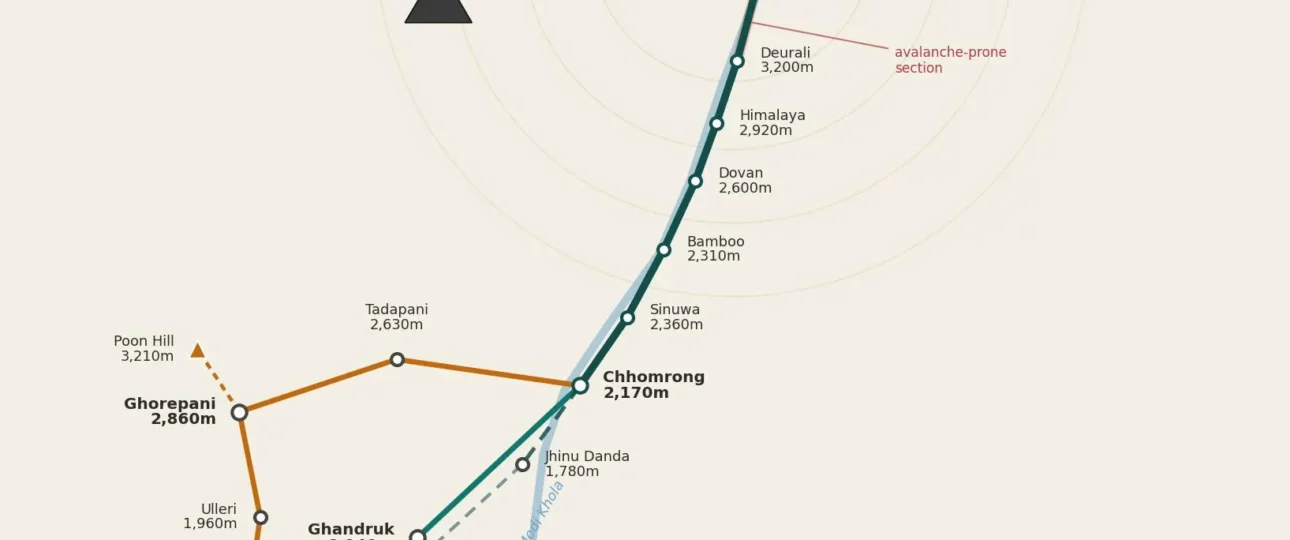
Annapurna Base Camp Trek Map
Most people who search for an Annapurna Base Camp trek map are not looking for a pretty picture. They want to answer a few practical questions: Where does this trek actually start? Which villages come in what order? How high does it get, and how fast? And why does every website quote a different distance?
Those are fair questions, because ABC maps are genuinely confusing. The trek has more than one starting point, more than one route to the same place, and a road network that keeps creeping deeper into the hills, which shortens the walk a little more every couple of years. A map printed in 2019 can send you looking for a trailhead that jeeps now drive straight past.
This guide walks through the route the way a map should: from the road, up through the villages, into the Annapurna Sanctuary, and back down. It covers the standard direct route, the popular Poon Hill variation, the elevation profile, honest distances, and the parts of the map that catch people out. The goal is that by the end you can look at any ABC map and know exactly what you’re seeing.
Quick Annapurna Base Camp Trek Map Overview
Here is the whole trek in one glance before we break it down.
- Region: Annapurna Sanctuary, inside the Annapurna Conservation Area, north of Pokhara in central Nepal.
- Highest point: Annapurna Base Camp (ABC), 4,130 m.
- Where it starts: A drive from Pokhara to a road-head trailhead. The common ones are Nayapul, Kimche, Ghandruk, Siwai and Jhinu Danda.
- Where it ends: Almost everyone descends via Jhinu Danda for the hot springs, then drives back to Pokhara.
- The route in one line: Pokhara → trailhead → Ghandruk → Chhomrong → Sinuwa → Bamboo → Dovan → Himalaya → Deurali → Machhapuchhre Base Camp (MBC) → Annapurna Base Camp (ABC).
- Two main route choices: the direct route (straight up the Modi Khola valley) or the Poon Hill variation (a longer loop through Ghorepani and Poon Hill that joins the main route at Chhomrong).
- Typical duration: 5 to 12 days on the trail, depending on where you start and whether you add Poon Hill.
The single most important thing a good ABC map shows is that the trek is a there-and-back walk up one river valley. Once you pass Chhomrong, every route converges onto the same trail to the base camp. Everything before Chhomrong is where the variations happen.
The Annapurna Base Camp Trek Route Map, Explained
The trek sits inside the Annapurna Sanctuary, a high glacial basin ringed by peaks that rise well above 7,000 metres. Annapurna I (8,091 m), Annapurna South, Hiunchuli and the sharp, unmistakable spire of Machhapuchhre (Fishtail) all crowd around the base camp. The only natural way into that basin is up the narrowing Modi Khola valley, and that corridor is what the trek follows.
Reading the route from bottom to top, here is the geography a map is trying to show you:
The road section. From Pokhara (around 820 m) a jeep climbs into the foothills to a trailhead. This part is a drive, not a walk, and a lot of maps blur the two together, which is where inflated distances come from.
The Gurung foothills. From the trailhead the trail climbs through terraced farmland and rhododendron forest to Ghandruk (about 1,940 m), a large, photogenic Gurung village with the first clear view of Annapurna South and Machhapuchhre.
The Chhomrong gateway. The trail drops to a river, crosses it, then climbs to Chhomrong (2,170 m). This village is the hinge of the whole trek. Every route passes through it, and it is the last real village before you enter the sanctuary corridor. Chhomrong is also where the famous stone staircase lives.
The forest corridor. After Chhomrong the trail descends to the Chhomrong Khola, crosses a suspension bridge, then climbs and follows the Modi Khola upstream through Sinuwa, Bamboo, Dovan and Himalaya. This is a shaded, humid, up-and-down stretch of forest with the river always somewhere below you.
The sanctuary gateway. The forest thins as you reach Deurali (roughly 3,200 m), the last settlement before the valley opens out. From here you’re in high, exposed terrain.
The two base camps. Machhapuchhre Base Camp, or MBC (about 3,700 m), sits at the mouth of the sanctuary. From MBC the final gentle climb leads to Annapurna Base Camp (ABC) at 4,130 m, where the valley opens into the full amphitheatre of peaks.
A simple way to hold the route in your head is to think of the trail as a line drawn up a single valley:
POKHARA (~820m) ─drive─► TRAILHEAD ─► GHANDRUK (1,940m) ─► CHHOMRONG (2,170m)
        │
        └─► SINUWA (~2,360m) ─► BAMBOO (~2,310m) ─► DOVAN (~2,600m) ─► HIMALAYA (~2,920m)
                │
                └─► DEURALI (~3,200m) ─► MBC (~3,700m) ─► ABC (4,130m)  ◄── highest point
The return follows the same line back down, then branches at Chhomrong toward Jhinu Danda and its hot springs before the final drive to Pokhara.
Annapurna Base Camp Trek Map With Major Stops and Elevations
The table below lists the main overnight stops on the direct route in walking order, with approximate elevations. Treat the elevation figures as close approximations. Different signboards, GPS devices and maps disagree by a few dozen metres for many of these villages, and that is normal.
| Stop | Approx. elevation | What it is |
|---|---|---|
| Pokhara | ~820 m | Trek’s base city; drive starts here |
| Nayapul / Siwai / Kimche | ~1,070–1,610 m | Common road-head trailheads |
| Ghandruk | ~1,940 m | Large Gurung village, first big mountain views |
| Jhinu Danda | ~1,780 m | Hot springs; usual return point |
| Chhomrong | 2,170 m | Gateway village, key trail junction |
| Lower / Upper Sinuwa | ~2,360 m | Forest ridge above the river |
| Bamboo | ~2,310 m | Small forest lodge cluster |
| Dovan | ~2,600 m | Riverside forest stop |
| Himalaya | ~2,920 m | Forest thinning, colder air |
| Deurali | ~3,200 m | Last settlement before the sanctuary |
| Machhapuchhre Base Camp (MBC) | ~3,700 m | Sanctuary gateway, common last-night stop |
| Annapurna Base Camp (ABC) | 4,130 m | The destination |
If a map you’re looking at shows villages out of this sequence, or skips Chhomrong entirely, be cautious. The order above is fixed on the ground.
The Annapurna Base Camp Trek Elevation Map
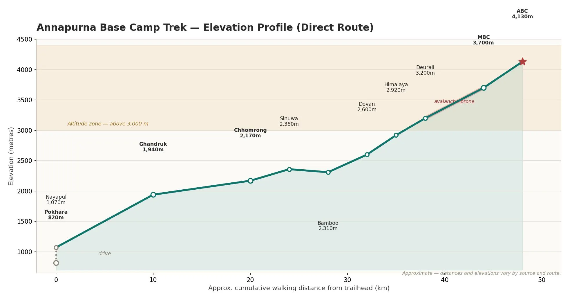
The elevation profile is where an ABC map earns its keep, because the numbers tell you where the hard days are and where altitude starts to matter.
The trek climbs from roughly 820 m in Pokhara to 4,130 m at ABC. That is a big vertical range, but it is spread over several days and the trail never crosses a high pass, so there’s no single altitude wall to get over. What the profile does have is a lot of ups and downs. The trail repeatedly drops to a river and climbs back out, so your legs do far more total ascent and descent than the start-to-finish gain suggests.
A rough sketch of the profile up the direct route looks like this:
4,130m ┤                                               ● ABC
       │                                          ● MBC
3,500m ┤                                     ● Deurali
       │                              ● Himalaya
3,000m ┤                         ● Dovan
       │              ● Chhomrong        (note: Sinuwa/Bamboo dip
2,500m ┤        ● Ghandruk                below Chhomrong first)
       │   ●
2,000m ┤ trailhead
       │●
   820m┤ Pokhara (drive)
       └──────────────────────────────────────────────────►
         lower foothills            forest            sanctuary
Two things stand out on the profile. First, the gain from Chhomrong onward is steady rather than steep, which is good for acclimatisation. Second, the biggest single jump in altitude happens near the end, on the climb from Deurali through MBC to ABC. That final stretch takes you past 3,500 m into thinner air, and it is where most people first notice the altitude. A well-planned itinerary keeps the last day’s sleeping elevation gain modest by overnighting at MBC before the short final push to ABC.
How to Read an Annapurna Base Camp Trek Map
A map is only useful if you know what its lines and numbers actually mean. A few practical points:
Separate the drive from the walk. The single most common mistake is treating the Pokhara-to-trailhead jeep ride as part of the trek. It isn’t. If a map shows a distance from Pokhara, check whether it includes the road section.
Check whether distances are one-way or round-trip. ABC is an out-and-back trek. A “48 km” figure and a “96 km” figure can describe the exact same trek, one counting the walk up, the other counting up and back.
Find Chhomrong first. It’s the junction that organises everything. If you can locate Chhomrong on a map, you can immediately tell which route the map is showing and where the variations split.
Read the elevation, not just the trail line. Two villages can sit close together on the map yet be separated by a steep descent to a river and a long climb back up. The horizontal distance hides the effort. Chhomrong to Sinuwa is the classic example.
Ignore exact GPS distances to the decimetre. Trail distances on ABC genuinely vary between sources because of route variations and where each measurement starts. Use them for rough planning, not precision.
Annapurna Base Camp Trek Route: A Representative Day-by-Day
Itineraries vary with your fitness, your starting trailhead and whether you add Poon Hill. The version below is a common, comfortable direct route that starts with a drive to Kimche or Ghandruk. Distances and times are approximate and depend heavily on pace and trail conditions.
| Day | Section | Approx. distance | Approx. time |
|---|---|---|---|
| 1 | Pokhara → drive to trailhead → Ghandruk (1,940 m) | Short walk | 2–4 hrs walking |
| 2 | Ghandruk → Chhomrong (2,170 m) | ~9–10 km | 5–6 hrs |
| 3 | Chhomrong → Bamboo (2,310 m) | ~7–8 km | 4–5 hrs |
| 4 | Bamboo → Deurali (3,200 m) | ~8–9 km | 5 hrs |
| 5 | Deurali → MBC → ABC (4,130 m) | ~7–8 km | 5–6 hrs |
| 6 | ABC → Bamboo (long descent) | ~15–16 km | 6–7 hrs |
| 7 | Bamboo → Jhinu Danda (hot springs) → drive to Pokhara | ~9 km + drive | 5–6 hrs |
Two details worth noting. The descent from ABC back to Bamboo is one of the longest single days on the trek, and it’s downhill the whole way, which is harder on the knees than people expect. And the final stop at Jhinu Danda is not just filler. The riverside hot springs are a genuinely good way to end the trek before the drive back.
Annapurna Base Camp Trek Map With Poon Hill
The Poon Hill variation is the most common change people make to the ABC map, and it’s worth understanding because it changes the whole first half of the trek.
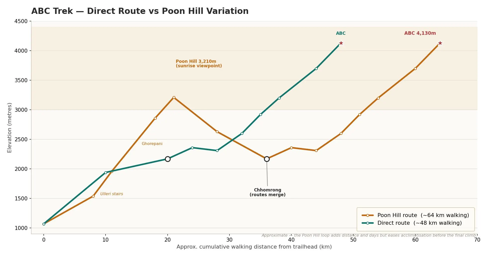
Instead of heading directly toward Chhomrong, this route swings west first. From a trailhead near Nayapul or Birethanti, it climbs through Tikhedhunga and the long stone staircase at Ulleri to reach Ghorepani (around 2,860 m). Before dawn, trekkers climb the short, steep trail to Poon Hill (3,210 m) for a wide sunrise panorama over Dhaulagiri and the Annapurna range. From Ghorepani the trail continues through Tadapani, drops to the Kimrong valley, and climbs to Chhomrong, where it rejoins the main ABC route.
In other words, Poon Hill is a loop bolted onto the front of the trek. After Chhomrong, the Poon Hill route and the direct route are identical.
Adding Poon Hill costs you two to three extra days and a fair amount of extra climbing, particularly the Ulleri stairs. In return you get a famous sunrise viewpoint, more rhododendron forest, and a gentler overall acclimatisation curve because you spend more days between 2,000 and 3,000 metres before the final push.
Direct ABC Route vs Poon Hill + ABC Route
| Feature | Direct ABC route | Poon Hill + ABC route |
|---|---|---|
| Typical length on trail | ~5–8 days | ~9–12 days |
| First half | Straight up the Modi Khola valley | Loop via Ghorepani and Poon Hill |
| Extra highlight | None; faster to the sanctuary | Poon Hill sunrise panorama |
| Acclimatisation | Steady but quicker | More gradual, extra days lower down |
| Best for | Fit trekkers short on time | First-timers who want the full experience |
| Where routes merge | — | At Chhomrong |
Neither is “the real route.” They are two legitimate ways to reach the same base camp. If your priority is reaching ABC efficiently, go direct. If your priority is seeing more of the region and easing into the altitude, take Poon Hill.
How Long Is the Annapurna Base Camp Trek?
This is the question that produces the most contradictory answers online, and the honest answer is: it depends, and the range is wide.
Depending on where you start and which route you take, the walking distance can land anywhere from roughly 40 km to well over 100 km round trip. Here’s why the figures scatter so much:
- Different starting trailheads. Starting from Siwai or Jhinu Danda cuts out the lower foothills entirely. Starting from Nayapul adds them back. That alone can swing the total by 20 km or more.
- One-way versus round-trip counting. Some sources quote the walk up only; others count up and down.
- The Poon Hill loop. Adding Ghorepani and Poon Hill can add 20 to 40 km.
- Where the road ends. As jeep roads have pushed deeper toward Siwai, Kimche and Jhinu, the walking distance has shrunk. Older maps still show longer figures because the road-head used to be lower.
So a “50 km trek” and a “100 km trek” can both be accurate descriptions of an ABC trip. When you see a distance, always ask what starting point and route it assumes. A trustworthy map tells you; a weak one just gives you a single headline number.
Major Trail Junctions and Villages to Know
A handful of points on the map matter more than the rest, because they’re where decisions get made or where the trail changes character.
Chhomrong is the master junction. Direct route, Poon Hill route and the return trail all pass through it. If you understand nothing else about the map, understand that Chhomrong is where routes meet and split.
Deurali is the threshold. Below it you’re in forest; above it you’re in the open high sanctuary. It’s the last settlement before the exposed final section.
MBC (Machhapuchhre Base Camp) is the natural last night before ABC. Sleeping here rather than pushing all the way to ABC and back keeps your altitude gain sensible.
Jhinu Danda is the return junction, where the descent trail branches off toward the hot springs and the road.
Ghorepani only appears if you take the Poon Hill route, and it’s the launch point for the Poon Hill sunrise.
Trail Terrain and Landscape
The map’s elevation numbers also predict what the trail looks and feels like, because the landscape changes in clear bands as you climb.
The lower sections around Ghandruk and Chhomrong are terraced farmland and Gurung villages with stone-paved paths and heavy staircases. Through the forest corridor from Sinuwa to Himalaya, the trail runs through dense, humid rhododendron and bamboo forest alongside the Modi Khola, often shaded and damp. Above Deurali the forest gives out to scrub, then open alpine terrain, and finally the glacial basin of the sanctuary itself, where the trail is surrounded by rock, snow and ice. In spring, the mid-elevation forest bands turn red and pink with rhododendron bloom, which is one of the main reasons spring is such a popular season.
Where Is the Hardest Part of the ABC Trek?
There’s no single killer climb, but a few sections stand out.
The Chhomrong staircase is the one most people remember. The trail drops a long way down stone steps to the Chhomrong Khola and climbs an equally long way back up, and on the return you do it in reverse when your legs are already tired.
On the Poon Hill route, the Ulleri stairs are a notoriously long, relentless stone staircase early in the trek.
The Deurali to ABC section is the hardest in a different way. It’s not steep, but it’s where altitude starts to bite. The climb through MBC to ABC feels slow because the air is thin, not because the trail is difficult.
And the long descent from ABC back down is deceptively hard on the knees and often underestimated.
How Altitude Affects the Route
ABC tops out at 4,130 m. That is high enough for altitude sickness to be a genuine risk, but low enough that the trek doesn’t require the long acclimatisation schedules of higher Himalayan routes.
The important stretch on the map is the top: from Deurali (~3,200 m) up through MBC (~3,700 m) to ABC (4,130 m). This is where you gain altitude fastest and where symptoms most often appear. The standard defence is built into a sensible itinerary rather than into rest days. Sleep at MBC before making the final climb to ABC, keep your daily sleeping-elevation gains moderate as you approach the sanctuary, drink plenty of water, and don’t rush the last section. If you develop worsening headache, nausea or dizziness, the correct response is to descend, and the good news on this trek is that descending brings quick relief because you drop elevation fast.
The Avalanche Section: The One Safety Point the Map Should Flag
There is one specific place on the ABC map that deserves a warning, and many maps leave it off. The stretch between Deurali and MBC runs through a narrow, steep-sided section of the valley that is known to be avalanche-prone, particularly in winter and early spring and after heavy snowfall.
This is not a reason to avoid the trek. It’s a reason to cross that section early in the morning, when snow is more stable, and not to linger there. Local guides watch conditions closely and will hold trekkers back or reroute timing when the risk is high. If you’re trekking in deep-snow conditions, this is exactly the kind of judgement call where having someone who knows the valley matters.
Best Time to Trek Annapurna Base Camp
Season doesn’t change the route, but it changes what the map delivers.
| Season | Months | What to expect |
|---|---|---|
| Autumn | Late Sept – Nov | Clearest skies, stable weather, busiest trails. The prime season. |
| Spring | March – May | Warm, rhododendron in bloom, generally good views. Very popular. |
| Winter | Dec – Feb | Cold, snow at altitude, higher avalanche risk, some high lodges quieter or closed. |
| Monsoon | June – Aug | Rain, cloud, leeches in the forest, landslide risk on roads. Fewest trekkers. |
Autumn and spring are the two seasons most people aim for, and for good reason. Winter is doable for prepared trekkers who don’t mind cold and understand the snow risk on the upper section. Monsoon is the hardest sell because cloud often hides the very peaks you came for.
Maps, GPS and Offline Navigation
The ABC trail is well-trodden and well-signed, and for most of its length it’s genuinely hard to get lost. That said, a few navigation habits are worth having.
Download an offline map before you go. Maps.me and Gaia GPS both have the ABC trail and villages marked and work without mobile signal, which you’ll lose for stretches of the upper valley. A paper trekking map of the Annapurna region is a good backup and useful for understanding the wider geography. Mobile coverage exists in the larger villages lower down but becomes patchy and then absent as you climb toward the sanctuary, so don’t rely on live data near the top. The main places people go wrong are the junctions around Chhomrong and the Kimrong valley on the Poon Hill route, where the trail branches; a quick check of an offline map at those points sorts it out.
Permits and Current Trekking Requirements (2026)
Permit rules are the part of any ABC map guide most likely to be out of date, so this section reflects the situation as of 2026, with an honest note where things are unsettled.
ACAP (Annapurna Conservation Area Permit) is the one non-negotiable document. It’s required for everyone entering the Annapurna region and is strictly enforced. As of 2026 it costs NPR 3,000 for foreign nationals and NPR 1,000 for SAARC nationals; children under 10 are exempt. It’s managed by the National Trust for Nature Conservation, and it’s checked at points such as Birethanti, the Ghandruk/Kimche area and Chhomrong. Carry the original permit and your passport, because photocopies and phone photos aren’t accepted at checkpoints.
TIMS card is where sources genuinely disagree. Official notices from the Nepal Tourism Board list TIMS as required on popular Annapurna routes, at a cost of around NPR 2,000 for foreign trekkers. In practice, enforcement on the ABC trail has been inconsistent, and many trekkers report that checkpoints verify the ACAP permit rather than TIMS. The safe approach is to have it arranged through your agency so a checkpoint check is never a problem.
The guide requirement is the other contested area. Since April 2023, the rule on the books requires foreign trekkers to trek with a licensed guide booked through a registered agency, and independent solo trekking is officially not permitted in the region. Enforcement in the Annapurna area has been uneven in practice, but the rule exists and is increasingly applied. Beyond the legal question, a guide is a real safety asset on the upper valley, especially through the avalanche-prone section and if altitude becomes an issue.
Because these rules shift, confirm the current position with a registered agency or the Nepal Tourism Board close to your trekking dates rather than relying on any single blog, including this one.
Common Annapurna Base Camp Map Mistakes
A quick checklist of the errors that trip people up when they plan from a map:
- Counting the jeep ride as trekking distance. The drive from Pokhara isn’t the walk.
- Trusting one distance figure. Always check the starting point and whether it’s one-way or round-trip.
- Assuming an old trailhead. Roads now reach Siwai, Kimche and Jhinu; the walk starts higher than older maps show.
- Underestimating the descent day. Coming down from ABC is long and hard on the knees.
- Ignoring elevation between nearby villages. Chhomrong to Sinuwa looks short and involves a steep river crossing.
- Overlooking the avalanche section. The Deurali–MBC stretch is the one part of the map worth timing carefully.
Which ABC Route Is Best for You?
Use this quick guide to match the map to your situation.
- Short on time and reasonably fit: Take the direct route with a jeep to a higher trailhead like Siwai or Kimche. You can reach ABC and return in under a week.
- First big trek, want the full experience: Take the Poon Hill variation. The extra days ease the altitude and add the sunrise viewpoint.
- Trekking in winter or deep snow: Go direct, keep it simple, and treat the upper section with respect. Guide judgement matters most here.
- Travelling with family or at a relaxed pace: Build in an extra night lower down, and don’t skip the MBC overnight before ABC.
FAQ about Annapurna Base Camp Trek Map
Where does the Annapurna Base Camp trek start? It starts with a drive from Pokhara to a road-head trailhead. The common ones are Nayapul, Kimche, Ghandruk, Siwai and Jhinu Danda. Which one you use depends on your itinerary and how much time you have.
Where does the trek end? Most trekkers finish by descending to Jhinu Danda for the hot springs, then driving back to Pokhara. Some end at Nayapul or Siwai instead.
How high is Annapurna Base Camp? ABC sits at 4,130 m. Machhapuchhre Base Camp (MBC), the usual last stop before it, is around 3,700 m.
How long is the Annapurna Base Camp trek in kilometres? Anywhere from roughly 40 km to over 100 km round trip, depending on the starting trailhead, whether you add Poon Hill, and how the distance is measured. There’s no single correct figure.
How many days does the ABC trek take? Typically 5 to 8 days for the direct route and 9 to 12 days if you include Poon Hill, plus travel days to and from Pokhara.
What is the standard ABC route order? Trailhead → Ghandruk → Chhomrong → Sinuwa → Bamboo → Dovan → Himalaya → Deurali → MBC → ABC, then back down the same way.
How does Poon Hill fit into the trek? It’s a loop added to the first half. You trek via Ghorepani and Poon Hill, then rejoin the main ABC route at Chhomrong. After Chhomrong both routes are identical.
Which route is the hardest part of the trek? The Chhomrong staircase and the final Deurali-to-ABC climb are the two hardest sections, for different reasons: the first is steep, the second is high.
Is there an avalanche risk on the route? Yes, on the narrow section between Deurali and MBC, mainly in winter and early spring or after heavy snow. Cross it early in the day and don’t linger there.
Do I need a permit for the ABC trek? Yes. The ACAP permit is mandatory and strictly enforced (NPR 3,000 for foreign nationals in 2026). A TIMS card and a licensed guide are also officially required, though enforcement of both has been inconsistent. Confirm current rules before you go.
Can I trek to ABC solo? Officially, foreign trekkers are required to use a licensed guide booked through a registered agency, a rule in place since 2023. Enforcement in the Annapurna region has varied, but the rule exists and is increasingly applied.
Do I need offline maps, and does my phone work on the trail? Download an offline map such as Maps.me or Gaia GPS before you start. Mobile coverage exists in lower villages but fades as you climb toward the sanctuary.
What’s the best time to trek to ABC? Autumn (late September to November) and spring (March to May) are the two prime seasons for clear views and stable weather.
How much altitude do you gain, and is altitude sickness a concern? You climb from around 820 m to 4,130 m. Altitude sickness is possible, mostly on the final push above Deurali. Sleep at MBC before ABC, ascend steadily, and descend if symptoms worsen.
Is the Annapurna Base Camp trek map different from the Annapurna Circuit map? Completely. They’re different treks with different routes, starting points and destinations. ABC goes up into the Annapurna Sanctuary to a base camp; the Circuit loops around the entire massif over a high pass.
Final Thoughts on Annapurna Base Camp Trek Map
An Annapurna Base Camp trek map looks complicated at first because of the multiple trailheads, the Poon Hill loop and the scatter of distance figures online. Once you see that it’s really a single walk up one river valley, with Chhomrong as the junction where routes meet, the whole thing clicks into place. Learn the sequence of villages, understand where the altitude and the one avalanche-prone section sit, and you can plan the trek with confidence.
If you’d rather have the route planning, permits and logistics handled for you, the team at WonderHikesNepal builds ABC itineraries around your available time and fitness, arranges the ACAP permit and licensed guides, sorts out transport to the right trailhead, and adapts the route (direct or via Poon Hill) to suit you. Reach out with your dates and we’ll map out a version of the trek that fits.