

Introduction to Mera Peak Elevation
If you are searching for the Mera Peak elevation, you have probably already met the problem: some pages say 6,476 metres, some say 6,461, and a few still say 6,654. They cannot all be right, and the difference matters when you are deciding whether a first 6,000-metre climb is realistic. The short answer is that Mera Peak’s highest point, Mera North, is 6,476 metres (21,247 feet), while the most frequently climbed Mera Central summit is 6,461 metres.
This guide gives you the full picture: the height of each summit, why published numbers disagree, the altitude of every stage from Lukla to the top, how Mera compares with other popular peaks, and what that height means for acclimatisation, safety and planning. Where sources disagree, I say so instead of choosing one quietly.
Mera Peak Height at a Glance
| Summit | Height | Notes |
|---|---|---|
| Mera North | 6,476 m (21,247 ft) | Highest point of the massif and the figure used for the mountain as a whole |
| Mera Central | 6,461 m (21,198 ft) | First climbed in 1953 and often the practical objective on commercial climbs |
| Mera South | 6,065 m (19,898 ft) | Lowest of the three and rarely the main goal |
Mera Peak lies in the Hinku Valley of the Solukhumbu district, east of the main Everest Base Camp trail, and is classified as a trekking peak. Its prominence is commonly listed at about 1,061 to 1,063 metres. That makes it the highest of the popular trekking peaks, though it is not the easiest to reach in terms of approach time.
The Three Summits Explained
Mera is not a single point but a massif with three main summits. From the south they appear lined up, with Mera South on one side, Mera Central in the middle and Mera North on the other.
Mera North (6,476 m). The true high point. It was first climbed in 1975 by a French party, according to Wikipedia, and it is the figure most references give for the peak’s elevation.
Mera Central (6,461 m). Only 15 metres lower than the north summit and the first to be climbed, on 20 May 1953, by Jimmy Roberts and Sen Tenzing. Several guidebooks and operators describe it as the summit most climbers actually reach, because the route is straightforward and the extra distance to the north summit takes additional effort. One climbing guide estimates that reaching Mera North adds around three hours.
Mera South (6,065 m). The lowest summit, which offers a different and more demanding approach and is climbed less often.
Sources do not fully agree on which summit is climbed most. Some operators say the north summit is the standard objective, while others say most groups stop at Central. If a specific summit matters to you, ask your operator which one the itinerary targets and whether the extra push to Mera North is included in good conditions.
Why You See Different Numbers for Mera Peak’s Altitude
The variation in published heights has a few separate causes, and understanding them stops the numbers from feeling contradictory.
- The 6,654 m error. Mera was long quoted at 6,654 metres, a figure often claimed to make it the highest trekking peak. Reference sources attribute this to a historical mapping mix-up in which Mera was confused with another summit. It is outdated and should not be used.
- Three summits, three heights. A page quoting 6,461 m may be describing Mera Central, while one quoting 6,476 m is describing Mera North. Both can be correct.
- Typos. Some operator pages print 6,467 m next to the correct 21,247 ft conversion. The feet figure is the giveaway: 21,247 ft equals 6,476 m.
- Rounding and conversions. Feet figures vary slightly between sources, for example 21,247 ft, 21,240 ft and 21,198 ft for different summits.
- Different survey data. Heights in the Himalaya are measured with different methods over time, so small differences between maps and datasets are normal.
The practical rule is simple. Use 6,476 metres for the mountain’s highest point and 6,461 metres if you know your route finishes on Mera Central. For the bigger picture of how Nepal’s heights are measured and compared, our guide to Nepal elevation, altitude and terrain is a good companion.
Mera Peak Elevation: Altitude Profile by Stage
The summit is only the last number in a long climb. The approach starts in Lukla and gains height steadily over several days before the glacier section begins. The table below combines the most commonly published figures. Camp and village heights differ slightly between operators, so treat them as a guide rather than exact measurements.
| Stage | Approx. altitude | What changes |
|---|---|---|
| Lukla | 2,860 m | Start of the trek after the flight from Kathmandu |
| Kothe | About 3,580 to 3,600 m | Forest and river valley, still low enough for easy sleep |
| Thangnak | About 4,350 m | Above the tree line, with the north face of Kusum Kanguru in view |
| Khare | About 5,045 m | The first night above 5,000 m for many itineraries; some sources list it slightly lower |
| Mera Base Camp | About 5,300 m | Foot of the glacier and a common acclimatisation base |
| Mera High Camp | About 5,800 m | Highest sleeping point before the summit push |
| Summit (Central or North) | 6,461 m or 6,476 m | Summit day, with views of five 8,000-metre peaks |
Trekking from Lukla to Mera Base Camp commonly takes seven to nine days according to one climbing guide, a gain of roughly 2,440 metres over that time. Spreading that gain across a week is what makes the later height manageable for most people.

The numbers that matter most
Three figures explain why this peak is demanding despite its reputation as a beginner objective.
- Total gain from Lukla: about 3,616 metres from Lukla (2,860 m) to the Mera North summit (6,476 m).
- Gain on the glacier days: from Base Camp (about 5,300 m) to High Camp (about 5,800 m) is roughly 500 metres, and from High Camp to the north summit is roughly 676 metres.
- Sleeping altitude: the highest night is typically spent at High Camp around 5,800 metres, which is higher than the base camp most trekkers reach on the Everest Base Camp trek.
The sleeping heights matter as much as the summit. At 5,800 metres, sleep is light, appetite drops and small tasks like putting on boots feel slow. Summit day starts in the dark and involves a long, steady glacier walk, so what you do in the days before matters more than anything on the day itself. Our main Mera Peak guide covers the route, the schedule and the climbing itself in detail.
How Mera Peak Compares With Other Popular Peaks
Putting the height in context helps you decide whether it suits your experience. The figures below use the most widely published heights. Some operators list slightly different numbers for Island Peak and Base Camp, and the Nepal government’s peak profile lists Island Peak at 6,165 metres, so check with your operator if precision matters.
| Place | Height | Type |
|---|---|---|
| Everest Base Camp | About 5,364 m | Trekking destination |
| Kala Patthar | About 5,545 m | Trekking viewpoint |
| Lobuche East | 6,119 m | Trekking peak |
| Island Peak (Imja Tse) | 6,189 m | Trekking peak |
| Mera North | 6,476 m | Trekking peak |
| Mount Everest | 8,848.86 m | Expedition peak |
Mera is taller than both Island Peak and Lobuche East, by roughly 290 and 360 metres respectively. Several operators describe it as technically easier than the two, because the standard route is a long, non-technical glacier walk rather than a steep ridge, while Lobuche East is generally described as the more technical of the three. That does not make Mera easy. The extra height is the main challenge, which is why acclimatisation is the key to success. For a comparison of the other Khumbu option, see our guide to Island Peak.
The Nepal Mountaineering Association manages the designated trekking peaks, and Mera, Island Peak and Lobuche East together account for the large majority of climbing permits, according to Nepali press reports. The popularity reflects their reputation among trekkers who want a 6,000-metre summit without expedition-level technical climbing.
What the Mera Peak Elevation Means in Practice
Numbers are abstract until you picture what 6,000 metres does to your body. At this height the air contains far less oxygen than at sea level, so every step requires more effort and recovery is slower. Cold, wind and glare add to the demand.
- Breathing and pace. Expect to move at a fraction of your normal walking speed. Short rests every few steps are normal, and a steady rhythm matters more than strength.
- Sleep. Disturbed sleep at 5,000 metres and above is common, and many people sleep poorly at High Camp however fit they are.
- Appetite and hydration. Appetite falls and dehydration comes quickly in dry air, so regular drinking and simple food are essential.
- Cold. Summit mornings are among the coldest of any trek, and hands and feet are the first to suffer. Layers, mitts and warm boots matter more than at lower altitudes.
- Decision-making. Altitude affects judgement as well as strength. That is why experienced guides set turn-around times and stick to them.
None of this is meant to put you off. It is the reason professional operators plan the approach slowly, and why the sensible response to height is respect and patience, not bravado.
Acclimatisation on the Mera Peak Route
Acclimatisation is the single most important factor in whether you reach the top. Climbing high but sleeping lower gives your body time to adapt, and a good itinerary builds that in.
On a typical schedule you gain height gradually from Lukla, with short days after Thangnak and Khare, and then add a deliberate acclimatisation day at or near Base Camp. One climbing guide describes a day hike up to about 5,600 metres from Base Camp, returning to sleep lower, as a routine step that raises success rates. Whatever the exact plan, a few principles apply.
- Do not rush the approach. Seven to nine days from Lukla to Base Camp is normal, and shortened schedules carry higher risk.
- Include a rest or acclimatisation day before the high camp, and treat it as part of the climb rather than a spare day.
- Drink regularly and eat even when your appetite is poor.
- Avoid alcohol and sleeping pills, which can dull your breathing at night.
- Tell your guide the truth about headaches, nausea or poor sleep. Honest reporting is the best safety tool.
If you have not trekked at altitude before, consider a lower trek first. Our guide to the Everest Base Camp elevation profile shows how the more familiar route builds height, and it is a useful way to find out how your body responds above 5,000 metres.
Altitude Sickness and Safety Above 5,000 Metres
Mild altitude symptoms such as headache, loss of appetite, nausea, dizziness and poor sleep are common on a Mera climb. Most are manageable with rest, fluids and a slower pace. The serious signs are different and should never be ignored: a severe headache that does not respond to rest, repeated vomiting, confusion, loss of balance, breathlessness at rest or a persistent wet cough.
The rule is simple: if symptoms worsen, descend. Going lower is the most reliable treatment, and waiting rarely helps. The Cleveland Clinic offers a clear, plain-language explanation of the symptoms and risks in its guide to altitude sickness, and you should speak to a travel-medicine professional before the trip, especially if you have heart or lung conditions or take regular medication.
Beyond altitude illness, glacier travel brings its own risks, including crevasses, changing snow conditions and rapid weather shifts. Reputable operators use licensed guides, fixed turn-around times and a clear evacuation plan. Ask how helicopter evacuation works and how it connects with your insurance before you leave.
Best Season for the Climb
The same two windows that suit most Himalayan climbs apply here: spring (roughly March to May) and autumn (roughly September to November). Operators commonly list March to May and September to November as the best periods. Autumn usually offers the clearest skies and stable weather after the monsoon, while spring is warmer but can be cloudier in the afternoons.
Winter climbs are possible but extremely cold and windy at High Camp, and the monsoon brings cloud, rain and heavy snow, which make views poor and glacier conditions less predictable. Whatever the season, flexibility matters. Weather windows at this height can be short, so a spare day in the itinerary is worth far more than it costs. Our guide to climbing in Nepal covers how seasons, permits and peaks fit together across the country.
Fitness and Gear for Mera Peak’s Height
You do not need technical climbing skills for the standard route, but you do need good general fitness and the right equipment. Wikipedia describes the standard route as technically straightforward for experienced climbers, with proper acclimatisation as the main hurdle.
Preparing your body
- Build endurance. Long hikes with a loaded pack, hill walking, stair climbing and cycling all help. Aim for weeks of consistent training, not a last-minute burst.
- Practise slow, steady walking. Pace is the most useful high-altitude skill.
- Train with your boots. Break in mountaineering boots well before departure.
- Get medical advice. A check-up with a doctor familiar with altitude is sensible, particularly for people with existing conditions.
Gear that matters at this height
- Insulated mountaineering boots, sized for thick socks and compatible with crampons.
- Four-season sleeping bag rated well below the lowest expected temperature, plus a liner.
- Down jacket and insulated trousers for High Camp and summit day.
- Warm gloves and mitts, with liners and spares.
- Goggles and sunglasses with strong UV protection, because glare on snow is intense.
- Harness, helmet, crampons and ice axe, which operators often provide or rent. Confirm what is included.
- Headlamp with spare batteries, since summit day starts in darkness.
Our companion article on Mera Peak climbing cost breaks down what packages typically include and which extras to budget for, which helps when you are comparing operators.
Is Mera Peak Realistic for a First 6,000-Metre Climb?
For many people, yes, with caveats. Mera is often recommended as a first 6,000-metre peak because the standard route involves glacier walking rather than steep technical climbing, and several operators describe it as easier technically than Island Peak and Lobuche East. In 2017 Hari Budha Magar became the first double above-knee amputee to climb a mountain over 6,000 metres by summiting Mera Peak, according to Wikipedia, a reminder of how achievable the route can be with preparation, skill and the right support.
But the height is real, and the remote Hinku Valley approach means you are several days from the nearest road. Whether Mera suits you depends on four things:
- Altitude experience. If you have already been above 5,000 metres without trouble, that is a good sign. If you have not, consider a lower trek first.
- Time. A slow, flexible schedule with buffer days is safer than a compressed one.
- Fitness. You need stamina for long days, not speed.
- Support. A licensed guide, a clear turn-around policy and a sensible evacuation plan are not optional.
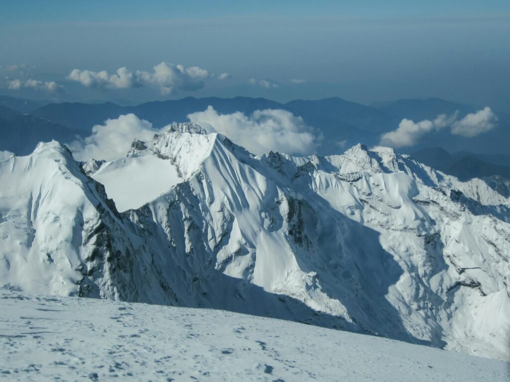
A Sample Altitude Plan, Stage by Stage
Every operator builds its own schedule, so treat this as an illustration of how the heights above are usually spread out rather than a fixed itinerary. The pattern is what matters: slow gains, a deliberate pause and a short, early summit push.
The lower approach (Lukla to Kothe). You fly to Lukla at about 2,860 metres and walk into the Hinku Valley, passing through forest, villages and river crossings. Sleeping heights stay below roughly 3,600 metres for the first part of the trek, which gives your body a gentle start. Use these days to find your walking rhythm and to check your boots and pack.
Above the tree line (Thangnak and Khare). The valley opens up and the air thins. Thangnak sits at about 4,350 metres and Khare at about 5,045 metres. This is where altitude symptoms often appear for the first time, so short walking days and plenty of fluids matter. Many itineraries add a rest or acclimatisation day around here.
Base Camp and the acclimatisation hike. At about 5,300 metres you are already higher than Everest Base Camp. A hike toward about 5,600 metres, returning to sleep at Base Camp, is a common way to prepare for High Camp. It is also when you learn the basics of crampons, ropes and glacier travel if your operator includes a skills session.
High Camp. At about 5,800 metres, this is the highest sleep of the trip. Most climbers eat early, rest and try to sleep, then wake after midnight or in the early hours to start the summit push.
Summit and descent. The glacier walk to the summit takes several hours, and the descent back to Base Camp or lower the same day is long and tiring. Many itineraries then continue to lower ground quickly, because sleep and appetite improve as you descend.
Summit Day: What the Height Feels Like Hour by Hour
Summit day is where the numbers become physical. The details vary by group and conditions, but the pattern is similar on most climbs.
- Before dawn. You start in darkness with a headlamp, warm layers and a clear idea of the turn-around time. The air is at its coldest, and you move slowly and steadily on the glacier roped to your guide.
- Early morning. The sun reaches the glacier, the temperature rises slightly and the views begin to open. Wind can still make it feel very cold.
- The final slope. The last section to the summit is steeper and slower, and breathing becomes laboured. Short, regular rests are normal.
- The top. Time at the summit is usually brief, because cold and altitude make lingering unwise. Take photos, drink something and begin the descent.
- The descent. Fatigue is the main danger now. Concentrate, keep drinking and follow your guide’s pace to avoid slips and mistakes.
Good guides set a turn-around time and keep to it, even if the summit is close. A summit reached too late is one of the most common ways minor problems become serious at altitude, so agree the plan before you set out.
Weather at High Camp and on the Glacier
Height changes weather as much as it changes your breathing. At and above High Camp, wind is often stronger than on the lower trail, temperatures fall sharply after sunset and afternoon cloud can close in quickly. Autumn and spring offer the most settled periods, but even then conditions can shift within hours. Keep a close eye on the forecast your guide receives, and be willing to wait a day for a better window if your schedule has room.
Snow conditions also affect how the glacier feels underfoot. Fresh snow can hide crevasses and slow progress, while hard, icy sections require careful crampon work. Reputable operators adjust the plan to the conditions rather than forcing a fixed timetable.
How to Read Operators’ Claims About Mera Peak’s Height
When you compare itineraries, a few details reveal how carefully an operator plans around the altitude.
- Do they quote the right figure? An operator still using 6,654 m may be copying old material. That does not make them unsafe, but it is worth asking about their planning.
- Do they say which summit they target? A good operator explains whether the plan is Mera Central or Mera North and what happens if conditions are poor.
- Is there an acclimatisation day? A schedule with no rest or hike-high day at Base Camp is a warning sign.
- Is a summit “guaranteed”? No one can guarantee a summit at altitude. Promises like that suggest pressure to push on when you should not.
- What is the evacuation plan? Ask who decides, how it is arranged and how it connects with your insurance.
Clear, specific answers are a good sign. Vague answers or very low prices are reasons to keep comparing.
Mera Peak or the Everest Base Camp Trek: Choosing by Height
Many travellers weigh a Mera climb against the classic Everest Base Camp trek, and height is the clearest way to compare them. Everest Base Camp sits at about 5,364 metres and Kala Patthar at about 5,545 metres, while Mera’s summit is more than 1,100 metres higher than Base Camp. You also sleep higher on Mera, at High Camp around 5,800 metres, compared with about 5,164 metres at Gorak Shep on the Everest trek.
The two trips also feel different. The Everest trail is busy, with lodges at every stage, regular villages and plenty of fellow trekkers. The Hinku Valley approach to Mera is quieter and more remote, with simpler facilities and a stronger sense of expedition. If you want views and culture with lodges and company, Everest Base Camp is the natural choice. If you want a summit, a more remote setting and are prepared for glacier travel and a higher sleeping altitude, Mera is the step up.
A good compromise for many people is to do Everest Base Camp first, see how they respond above 5,000 metres, and plan Mera as a later trip. Others combine experience on lower peaks before attempting a 6,000-metre summit. Either way, honest self-assessment beats ambition. Our guide to the Everest Base Camp elevation profile shows how that route builds height, which is useful context when you compare plans.
Permits and Regulations Linked to the Height
Mera is one of the trekking peaks regulated by the Nepal Mountaineering Association, which issues climbing permits and works with licensed operators. You also need the usual trekking permits for the region you pass through, and the rules for guides and agencies apply. Because permit rules and fees change, check current requirements with your operator before booking. Our guide to mountaineering in Nepal explains how the permit system works for peaks, and the permits article covers trekking fees and rules in detail.
Common Mistakes When Planning Around Height
- Quoting the wrong number. Using 6,654 m, or mixing up the north and central summits, can lead to confusion when you compare operators.
- Underestimating the sleeping altitude. High Camp at about 5,800 m is higher than most trekkers have ever slept.
- Treating the acclimatisation day as optional. It is part of the plan, not a bonus.
- Skipping a buffer day. Weather and flight delays are common, and a tight schedule invites risky decisions.
- Ignoring early symptoms. A headache that worsens is a reason to rest or descend.
- Choosing price over safety. Very cheap packages may cut acclimatisation, guide quality or equipment.
- Assuming “trekking peak” means easy. It is a permit category, not a difficulty grade.
Pre-Climb Checklist
- Confirm which summit your itinerary targets and its height.
- Check the schedule for at least seven to nine days of approach and an acclimatisation day.
- Train consistently for several weeks with a loaded pack.
- Arrange insurance that covers climbing to 6,500 metres and helicopter evacuation.
- Test your boots and cold-weather gear before you leave home.
- Ask about guide ratios, turn-around times and the evacuation plan.
- Build in a spare day for weather and flights.
- Agree your own limits in advance and share them with your guide.
Final Thoughts on Mera Peak’s Height
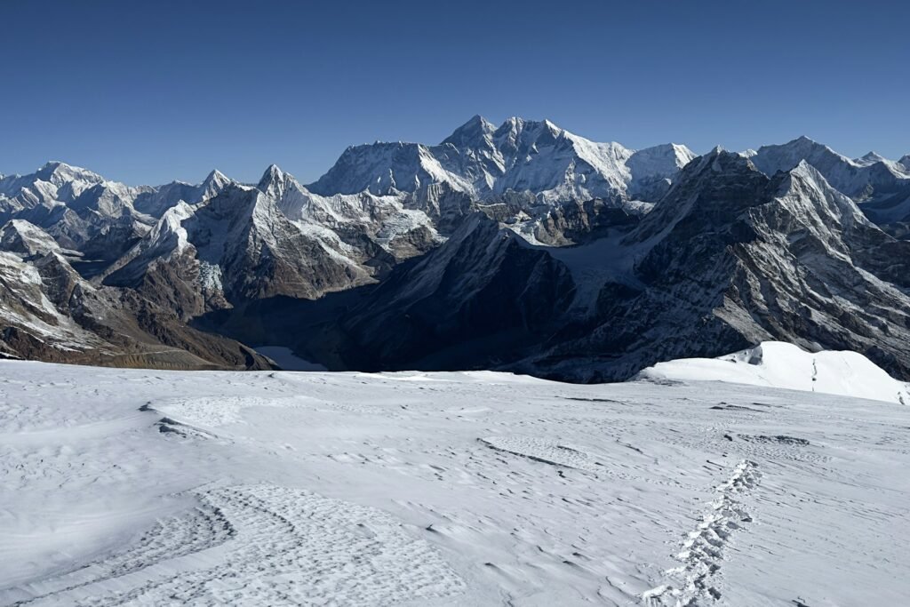
The numbers are simple once you separate them: 6,476 metres for the highest summit, 6,461 for the central one, 6,065 for the south one, and ignore the old 6,654 figure. What is harder to capture in a number is what that height asks of you. It rewards patience, slow walking and honest communication with your guide, and it punishes rushing. If you plan the approach carefully and respect the altitude, a 6,000-metre summit with views over Everest, Lhotse, Makalu and beyond is within reach for many fit trekkers.
For a concise reference on the mountain’s summits and climbing history, Wikipedia keeps an entry on Mera Peak, and Much Better Adventures has a practical Mera Peak climbing guide with route and acclimatisation detail for comparison.
Frequently Asked Questions About Mera Peak’s Height
1. How high is Mera Peak?
The highest summit, Mera North, is 6,476 metres (21,247 feet). Mera Central is 6,461 metres and Mera South is 6,065 metres.
2. Is Mera Peak 6,476 m or 6,654 m?
6,476 metres is the figure used by reference sources today. The 6,654 m figure is an old error linked to a mapping confusion and should not be used.
3. Which Mera Peak summit do most climbers reach?
Sources differ. Several operators say most groups climb Mera Central (6,461 m), while others list Mera North as the standard objective. Ask your operator which summit your itinerary targets.
4. Is Mera Peak the highest trekking peak in Nepal?
It is widely described as the highest of the popular trekking peaks, standing above Island Peak (6,189 m) and Lobuche East (6,119 m).
5. How high is Mera Peak Base Camp and High Camp?
Base Camp is commonly listed at about 5,300 metres and High Camp at about 5,800 metres. Exact figures vary slightly between operators.
6. How much height do you gain from Lukla to the summit?
Roughly 3,600 metres in total, from Lukla at about 2,860 metres to the north summit at 6,476 metres, spread over many days.
7. Is Mera Peak harder than Island Peak?
It is higher, but several operators describe it as technically easier because the standard route is a non-technical glacier walk. The extra altitude and the longer approach are the main challenges.
8. How many days do you need to acclimatise on Mera Peak?
The approach from Lukla to Base Camp commonly takes seven to nine days, usually with an acclimatisation day and a higher day hike before moving up to High Camp.
9. Can beginners climb Mera Peak?
Many fit trekkers do, but altitude is the main risk. Prior experience above 5,000 metres, a slow schedule and a licensed guide all improve safety and success.
10. What is the best time to climb Mera Peak?
Spring (March to May) and autumn (September to November) offer the most stable weather and clearest views. Winter is very cold and the monsoon brings cloud and snow.
Plan Your Climb With Wonder Hikes Nepal
Understanding the Mera Peak elevation is the first step. Building an itinerary with enough acclimatisation, the right summit goal and a sensible safety plan is the second. Tell us your dates, experience and fitness, and we will help you plan a climb that fits your schedule and your limits. The quickest way to reach us is on WhatsApp.
Chat with Wonder Hikes Nepal on WhatsApp: +977 986-0221055
Ready to plan your trek?
Tell us your dates and group size. We reply on WhatsApp within a few hours.